You are here: Home > Network List > TA - USArray Transportable Network (new EarthScope stations) Stations List
> Station Q23A Hartsel, CO, USA > Earthquake Result Viewer
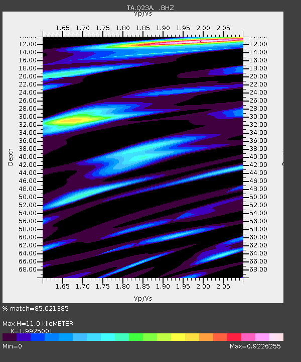
Q23A Hartsel, CO, USA - Earthquake Result Viewer
| Earthquake location: |
Kermadec Islands Region |
| Earthquake latitude/longitude: |
-31.5/-178.8 |
| Earthquake time(UTC): |
2009/05/16 (136) 00:53:52 GMT |
| Earthquake Depth: |
55 km |
| Earthquake Magnitude: |
6.1 MB, 6.5 MW, 6.3 MW |
| Earthquake Catalog/Contributor: |
WHDF/NEIC |
|
| Network: |
TA USArray Transportable Network (new EarthScope stations) |
| Station: |
Q23A Hartsel, CO, USA |
| Lat/Lon: |
38.90 N/105.83 W |
| Elevation: |
2774 m |
|
| Distance: |
97.5 deg |
| Az: |
48.797 deg |
| Baz: |
235.439 deg |
| Ray Param: |
0.0401669 |
| Estimated Moho Depth: |
11.0 km |
| Estimated Crust Vp/Vs: |
1.99 |
| Assumed Crust Vp: |
6.159 km/s |
| Estimated Crust Vs: |
3.091 km/s |
| Estimated Crust Poisson's Ratio: |
0.33 |
|
| Radial Match: |
85.021385 % |
| Radial Bump: |
400 |
| Transverse Match: |
53.75586 % |
| Transverse Bump: |
400 |
| SOD ConfigId: |
2760 |
| Insert Time: |
2010-03-07 04:57:32.769 +0000 |
| GWidth: |
2.5 |
| Max Bumps: |
400 |
| Tol: |
0.001 |
|

Signal To Noise
| Channel | StoN | STA | LTA |
| TA:Q23A: :BHZ:20090516T01:06:49.200022Z | 5.910744 | 5.278365E-7 | 8.930119E-8 |
| TA:Q23A: :BHN:20090516T01:06:49.200022Z | 1.117706 | 1.9068318E-7 | 1.7060228E-7 |
| TA:Q23A: :BHE:20090516T01:06:49.200022Z | 1.1114122 | 2.1188593E-7 | 1.906457E-7 |
| Arrivals |
| Ps | 1.8 SECOND |
| PpPs | 5.3 SECOND |
| PsPs/PpSs | 7.1 SECOND |


