You are here: Home > Network List > TA - USArray Transportable Network (new EarthScope stations) Stations List
> Station T11A Corn Creek, Alamo, NV, USA > Earthquake Result Viewer
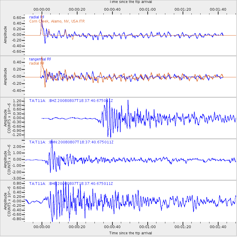
T11A Corn Creek, Alamo, NV, USA - Earthquake Result Viewer
| Earthquake location: |
Andreanof Islands, Aleutian Is. |
| Earthquake latitude/longitude: |
52.2/-175.7 |
| Earthquake time(UTC): |
2008/08/07 (220) 18:30:03 GMT |
| Earthquake Depth: |
12 km |
| Earthquake Magnitude: |
5.6 MB, 5.5 MS, 5.8 MW, 5.8 MW |
| Earthquake Catalog/Contributor: |
WHDF/NEIC |
|
| Network: |
TA USArray Transportable Network (new EarthScope stations) |
| Station: |
T11A Corn Creek, Alamo, NV, USA |
| Lat/Lon: |
37.24 N/115.22 W |
| Elevation: |
1402 m |
|
| Distance: |
44.2 deg |
| Az: |
85.009 deg |
| Baz: |
309.783 deg |
| Ray Param: |
0.07207808 |
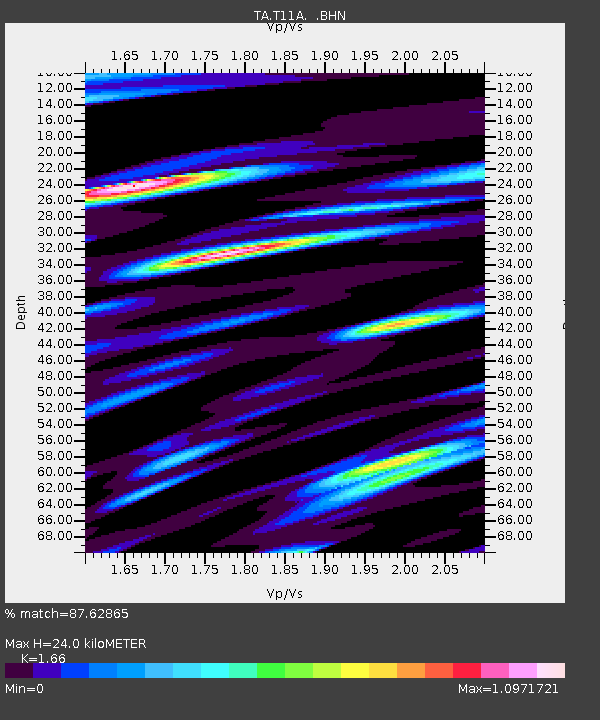
| Estimated Moho Depth: |
24.0 km |
| Estimated Crust Vp/Vs: |
1.66 |
| Assumed Crust Vp: |
6.276 km/s |
| Estimated Crust Vs: |
3.781 km/s |
| Estimated Crust Poisson's Ratio: |
0.22 |
|
| Radial Match: |
87.62865 % |
| Radial Bump: |
400 |
| Transverse Match: |
82.6704 % |
| Transverse Bump: |
400 |
| SOD ConfigId: |
2504 |
| Insert Time: |
2010-03-07 04:58:26.315 +0000 |
| GWidth: |
2.5 |
| Max Bumps: |
400 |
| Tol: |
0.001 |
|
Signal To Noise
| Channel | StoN | STA | LTA |
| TA:T11A: :BHN:20080807T18:37:40.675011Z | 9.643848 | 4.9904844E-7 | 5.1747854E-8 |
| TA:T11A: :BHE:20080807T18:37:40.675011Z | 2.4880147 | 1.4126326E-7 | 5.67775E-8 |
| TA:T11A: :BHZ:20080807T18:37:40.675011Z | 5.946937 | 1.9504022E-7 | 3.2796752E-8 |
| Arrivals |
| Ps | 2.7 SECOND |
| PpPs | 9.5 SECOND |
| PsPs/PpSs | 12 SECOND |


