You are here: Home > Network List > UW - Pacific Northwest Regional Seismic Network Stations List
> Station IZEE Izee, OR, USA > Earthquake Result Viewer
IZEE Izee, OR, USA - Earthquake Result Viewer

| Earthquake location: |
Chile-Bolivia Border Region |
| Earthquake latitude/longitude: |
-21.9/-68.6 |
| Earthquake time(UTC): |
2019/10/06 (279) 10:40:55 GMT |
| Earthquake Depth: |
112 km |
| Earthquake Magnitude: |
5.9 Mww |
| Earthquake Catalog/Contributor: |
NEIC PDE/us |
|
| Network: |
UW Pacific Northwest Regional Seismic Network |
| Station: |
IZEE Izee, OR, USA |
| Lat/Lon: |
44.08 N/119.50 W |
| Elevation: |
1293 m |
|
| Distance: |
80.5 deg |
| Az: |
325.437 deg |
| Baz: |
133.025 deg |
| Ray Param: |
0.047968857 |
| Estimated Moho Depth: |
24.0 km |
| Estimated Crust Vp/Vs: |
2.03 |
| Assumed Crust Vp: |
6.571 km/s |
| Estimated Crust Vs: |
3.241 km/s |
| Estimated Crust Poisson's Ratio: |
0.34 |
|
| Radial Match: |
92.5226 % |
| Radial Bump: |
112 |
| Transverse Match: |
44.95604 % |
| Transverse Bump: |
375 |
| SOD ConfigId: |
19053131 |
| Insert Time: |
2019-10-20 10:50:31.825 +0000 |
| GWidth: |
2.5 |
| Max Bumps: |
400 |
| Tol: |
0.001 |
|
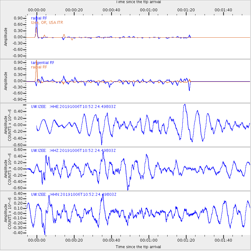
Signal To Noise
| Channel | StoN | STA | LTA |
| UW:IZEE: :HHZ:20191006T10:52:24.49803Z | 2.0403624 | 1.8708978E-7 | 9.169438E-8 |
| UW:IZEE: :HHN:20191006T10:52:24.49803Z | 2.7400222 | 1.9482056E-7 | 7.1101816E-8 |
| UW:IZEE: :HHE:20191006T10:52:24.49803Z | 2.1566198 | 2.3768558E-7 | 1.102121E-7 |
| Arrivals |
| Ps | 3.8 SECOND |
| PpPs | 11 SECOND |
| PsPs/PpSs | 15 SECOND |


