You are here: Home > Network List > GS - US Geological Survey Networks Stations List
> Station KAN08 Pence Farm, Harper, KS, USA > Earthquake Result Viewer
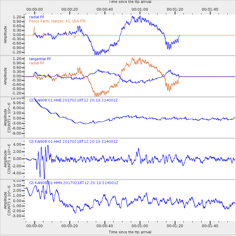
KAN08 Pence Farm, Harper, KS, USA - Earthquake Result Viewer
*The percent match for this event was below the threshold and hence no stack was calculated.
| Earthquake location: |
Jujuy Province, Argentina |
| Earthquake latitude/longitude: |
-23.9/-66.7 |
| Earthquake time(UTC): |
2017/02/18 (049) 12:10:15 GMT |
| Earthquake Depth: |
201 km |
| Earthquake Magnitude: |
6.3 Mww |
| Earthquake Catalog/Contributor: |
NEIC PDE/us |
|
| Network: |
GS US Geological Survey Networks |
| Station: |
KAN08 Pence Farm, Harper, KS, USA |
| Lat/Lon: |
37.23 N/97.97 W |
| Elevation: |
375 m |
|
| Distance: |
67.6 deg |
| Az: |
333.362 deg |
| Baz: |
149.067 deg |
| Ray Param: |
$rayparam |
*The percent match for this event was below the threshold and hence was not used in the summary stack. |
|
| Radial Match: |
38.31606 % |
| Radial Bump: |
400 |
| Transverse Match: |
37.99769 % |
| Transverse Bump: |
400 |
| SOD ConfigId: |
1992691 |
| Insert Time: |
2017-03-04 12:14:01.645 +0000 |
| GWidth: |
2.5 |
| Max Bumps: |
400 |
| Tol: |
0.001 |
|
Signal To Noise
| Channel | StoN | STA | LTA |
| GS:KAN08:01:HHZ:20170218T12:20:19.314001Z | 4.998084 | 1.8158983E-6 | 3.6331886E-7 |
| GS:KAN08:01:HHN:20170218T12:20:19.314001Z | 1.612795 | 4.865983E-6 | 3.0171122E-6 |
| GS:KAN08:01:HHE:20170218T12:20:19.314001Z | 1.4456519 | 5.4835687E-6 | 3.793146E-6 |
| Arrivals |
| Ps | |
| PpPs | |
| PsPs/PpSs | |


