You are here: Home > Network List > GS - US Geological Survey Networks Stations List
> Station KAN09 East Station, Caldwell, KS, USA > Earthquake Result Viewer
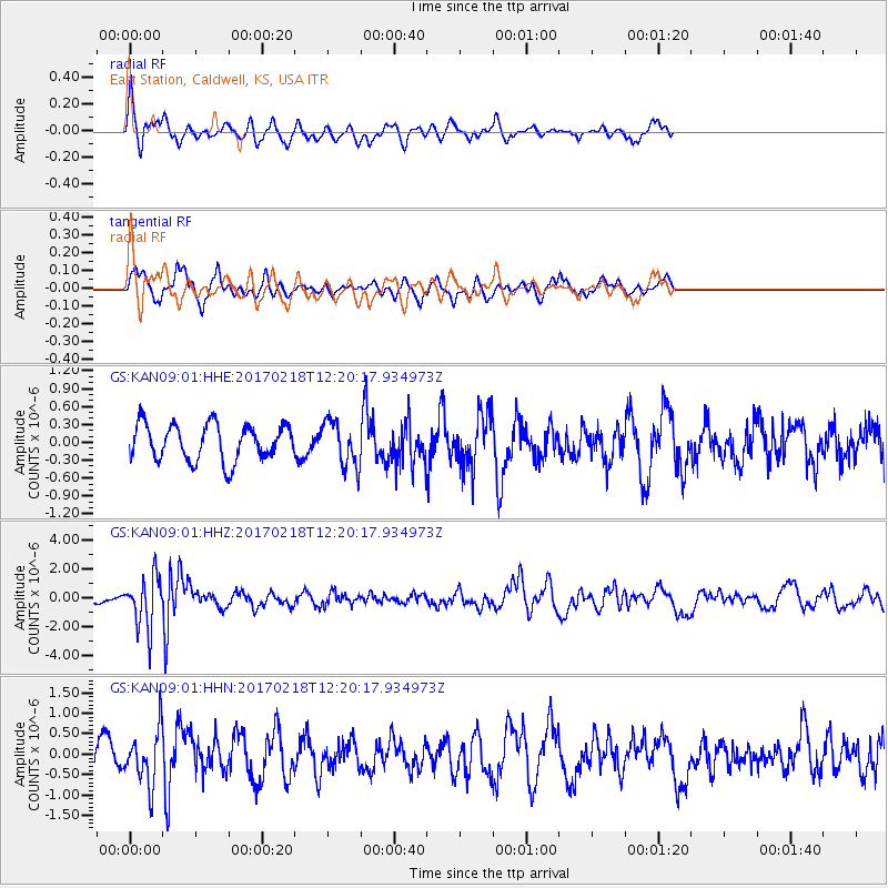
KAN09 East Station, Caldwell, KS, USA - Earthquake Result Viewer
*The percent match for this event was below the threshold and hence no stack was calculated.
| Earthquake location: |
Jujuy Province, Argentina |
| Earthquake latitude/longitude: |
-23.9/-66.7 |
| Earthquake time(UTC): |
2017/02/18 (049) 12:10:15 GMT |
| Earthquake Depth: |
201 km |
| Earthquake Magnitude: |
6.3 Mww |
| Earthquake Catalog/Contributor: |
NEIC PDE/us |
|
| Network: |
GS US Geological Survey Networks |
| Station: |
KAN09 East Station, Caldwell, KS, USA |
| Lat/Lon: |
37.14 N/97.62 W |
| Elevation: |
371 m |
|
| Distance: |
67.4 deg |
| Az: |
333.573 deg |
| Baz: |
149.361 deg |
| Ray Param: |
$rayparam |
*The percent match for this event was below the threshold and hence was not used in the summary stack. |
|
| Radial Match: |
60.18197 % |
| Radial Bump: |
336 |
| Transverse Match: |
63.841324 % |
| Transverse Bump: |
351 |
| SOD ConfigId: |
1992691 |
| Insert Time: |
2017-03-04 12:14:03.059 +0000 |
| GWidth: |
2.5 |
| Max Bumps: |
400 |
| Tol: |
0.001 |
|
Signal To Noise
| Channel | StoN | STA | LTA |
| GS:KAN09:01:HHZ:20170218T12:20:17.934973Z | 5.135127 | 1.7816506E-6 | 3.4695353E-7 |
| GS:KAN09:01:HHN:20170218T12:20:17.934973Z | 1.8140736 | 6.403429E-7 | 3.5298618E-7 |
| GS:KAN09:01:HHE:20170218T12:20:17.934973Z | 1.2373813 | 3.7433367E-7 | 3.0252087E-7 |
| Arrivals |
| Ps | |
| PpPs | |
| PsPs/PpSs | |


