You are here: Home > Network List > TA - USArray Transportable Network (new EarthScope stations) Stations List
> Station T11A Corn Creek, Alamo, NV, USA > Earthquake Result Viewer
T11A Corn Creek, Alamo, NV, USA - Earthquake Result Viewer
| Earthquake location: |
South Of Fiji Islands |
| Earthquake latitude/longitude: |
-26.3/-177.7 |
| Earthquake time(UTC): |
2007/07/18 (199) 00:07:35 GMT |
| Earthquake Depth: |
10 km |
| Earthquake Magnitude: |
5.8 MB, 5.9 MS, 6.1 MW, 6.0 MW |
| Earthquake Catalog/Contributor: |
WHDF/NEIC |
|
| Network: |
TA USArray Transportable Network (new EarthScope stations) |
| Station: |
T11A Corn Creek, Alamo, NV, USA |
| Lat/Lon: |
37.24 N/115.22 W |
| Elevation: |
1402 m |
|
| Distance: |
86.3 deg |
| Az: |
45.194 deg |
| Baz: |
232.948 deg |
| Ray Param: |
0.044173107 |
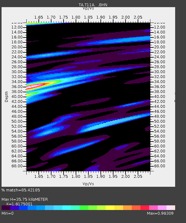
| Estimated Moho Depth: |
35.75 km |
| Estimated Crust Vp/Vs: |
1.62 |
| Assumed Crust Vp: |
6.276 km/s |
| Estimated Crust Vs: |
3.88 km/s |
| Estimated Crust Poisson's Ratio: |
0.19 |
|
| Radial Match: |
85.42185 % |
| Radial Bump: |
400 |
| Transverse Match: |
71.58755 % |
| Transverse Bump: |
400 |
| SOD ConfigId: |
2564 |
| Insert Time: |
2010-03-07 04:59:09.834 +0000 |
| GWidth: |
2.5 |
| Max Bumps: |
400 |
| Tol: |
0.001 |
|
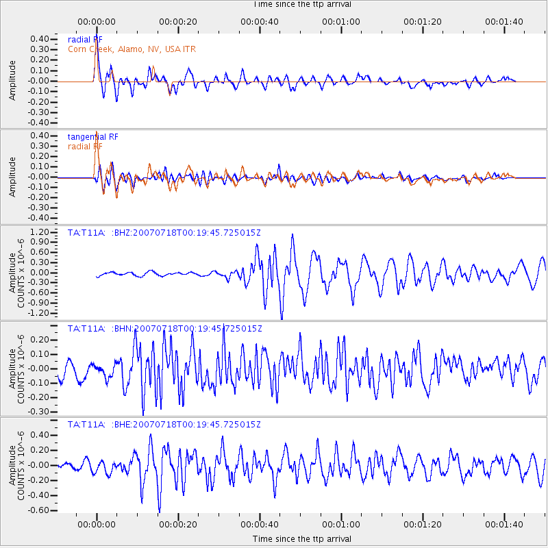
Signal To Noise
| Channel | StoN | STA | LTA |
| TA:T11A: :BHN:20070718T00:19:45.725015Z | 1.2223169 | 5.074999E-8 | 4.1519506E-8 |
| TA:T11A: :BHE:20070718T00:19:45.725015Z | 2.1038065 | 8.826235E-8 | 4.1953644E-8 |
| TA:T11A: :BHZ:20070718T00:19:45.725015Z | 1.8035632 | 9.158556E-8 | 5.0780347E-8 |
| Arrivals |
| Ps | 3.6 SECOND |
| PpPs | 15 SECOND |
| PsPs/PpSs | 18 SECOND |


