You are here: Home > Network List > TA - USArray Transportable Network (new EarthScope stations) Stations List
> Station T11A Corn Creek, Alamo, NV, USA > Earthquake Result Viewer
T11A Corn Creek, Alamo, NV, USA - Earthquake Result Viewer

| Earthquake location: |
Central Mid-Atlantic Ridge |
| Earthquake latitude/longitude: |
0.7/-30.3 |
| Earthquake time(UTC): |
2007/07/03 (184) 08:26:00 GMT |
| Earthquake Depth: |
10 km |
| Earthquake Magnitude: |
5.8 MB, 5.9 MS, 6.3 MW, 6.1 MW |
| Earthquake Catalog/Contributor: |
WHDF/NEIC |
|
| Network: |
TA USArray Transportable Network (new EarthScope stations) |
| Station: |
T11A Corn Creek, Alamo, NV, USA |
| Lat/Lon: |
37.24 N/115.22 W |
| Elevation: |
1402 m |
|
| Distance: |
85.5 deg |
| Az: |
307.121 deg |
| Baz: |
92.481 deg |
| Ray Param: |
0.044690087 |
| Estimated Moho Depth: |
31.0 km |
| Estimated Crust Vp/Vs: |
1.61 |
| Assumed Crust Vp: |
6.276 km/s |
| Estimated Crust Vs: |
3.892 km/s |
| Estimated Crust Poisson's Ratio: |
0.19 |
|
| Radial Match: |
80.31745 % |
| Radial Bump: |
400 |
| Transverse Match: |
70.96495 % |
| Transverse Bump: |
400 |
| SOD ConfigId: |
2564 |
| Insert Time: |
2010-03-07 04:59:16.205 +0000 |
| GWidth: |
2.5 |
| Max Bumps: |
400 |
| Tol: |
0.001 |
|
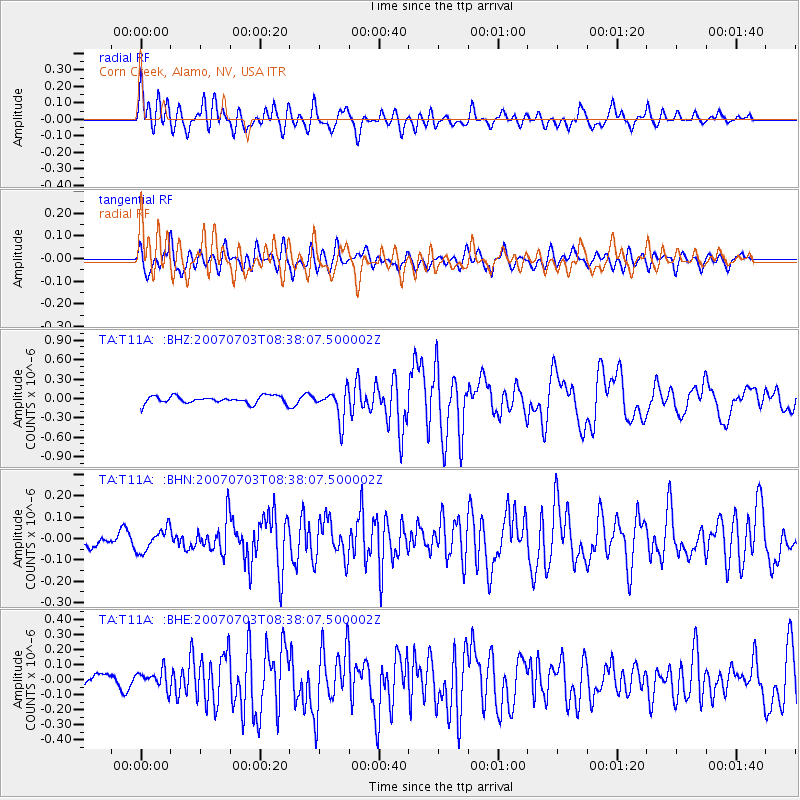
Signal To Noise
| Channel | StoN | STA | LTA |
| TA:T11A: :BHN:20070703T08:38:07.500002Z | 1.1960672 | 5.392106E-8 | 4.5081965E-8 |
| TA:T11A: :BHE:20070703T08:38:07.500002Z | 1.1499131 | 6.125333E-8 | 5.326779E-8 |
| TA:T11A: :BHZ:20070703T08:38:07.500002Z | 4.022778 | 2.3316748E-7 | 5.7961806E-8 |
| Arrivals |
| Ps | 3.1 SECOND |
| PpPs | 13 SECOND |
| PsPs/PpSs | 16 SECOND |


