You are here: Home > Network List > TA - USArray Transportable Network (new EarthScope stations) Stations List
> Station T11A Corn Creek, Alamo, NV, USA > Earthquake Result Viewer
T11A Corn Creek, Alamo, NV, USA - Earthquake Result Viewer
| Earthquake location: |
Near Coast Of Central Chile |
| Earthquake latitude/longitude: |
-32.0/-71.3 |
| Earthquake time(UTC): |
2007/06/28 (179) 19:25:21 GMT |
| Earthquake Depth: |
69 km |
| Earthquake Magnitude: |
5.5 MB, 5.7 MW, 5.6 MW |
| Earthquake Catalog/Contributor: |
WHDF/NEIC |
|
| Network: |
TA USArray Transportable Network (new EarthScope stations) |
| Station: |
T11A Corn Creek, Alamo, NV, USA |
| Lat/Lon: |
37.24 N/115.22 W |
| Elevation: |
1402 m |
|
| Distance: |
80.2 deg |
| Az: |
325.845 deg |
| Baz: |
143.295 deg |
| Ray Param: |
0.04832844 |
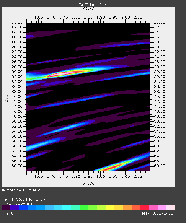
| Estimated Moho Depth: |
30.5 km |
| Estimated Crust Vp/Vs: |
1.74 |
| Assumed Crust Vp: |
6.276 km/s |
| Estimated Crust Vs: |
3.602 km/s |
| Estimated Crust Poisson's Ratio: |
0.25 |
|
| Radial Match: |
82.25462 % |
| Radial Bump: |
400 |
| Transverse Match: |
70.54545 % |
| Transverse Bump: |
400 |
| SOD ConfigId: |
2564 |
| Insert Time: |
2010-03-07 04:59:17.099 +0000 |
| GWidth: |
2.5 |
| Max Bumps: |
400 |
| Tol: |
0.001 |
|

Signal To Noise
| Channel | StoN | STA | LTA |
| TA:T11A: :BHN:20070628T19:36:53.075017Z | 5.285848 | 1.4948324E-7 | 2.8279896E-8 |
| TA:T11A: :BHE:20070628T19:36:53.075017Z | 1.8620336 | 1.2269561E-7 | 6.589334E-8 |
| TA:T11A: :BHZ:20070628T19:36:53.075017Z | 8.410605 | 4.4794973E-7 | 5.3260102E-8 |
| Arrivals |
| Ps | 3.7 SECOND |
| PpPs | 13 SECOND |
| PsPs/PpSs | 17 SECOND |


