You are here: Home > Network List > TA - USArray Transportable Network (new EarthScope stations) Stations List
> Station O17K Koliganek, Bristol Bay, AK, USA > Earthquake Result Viewer
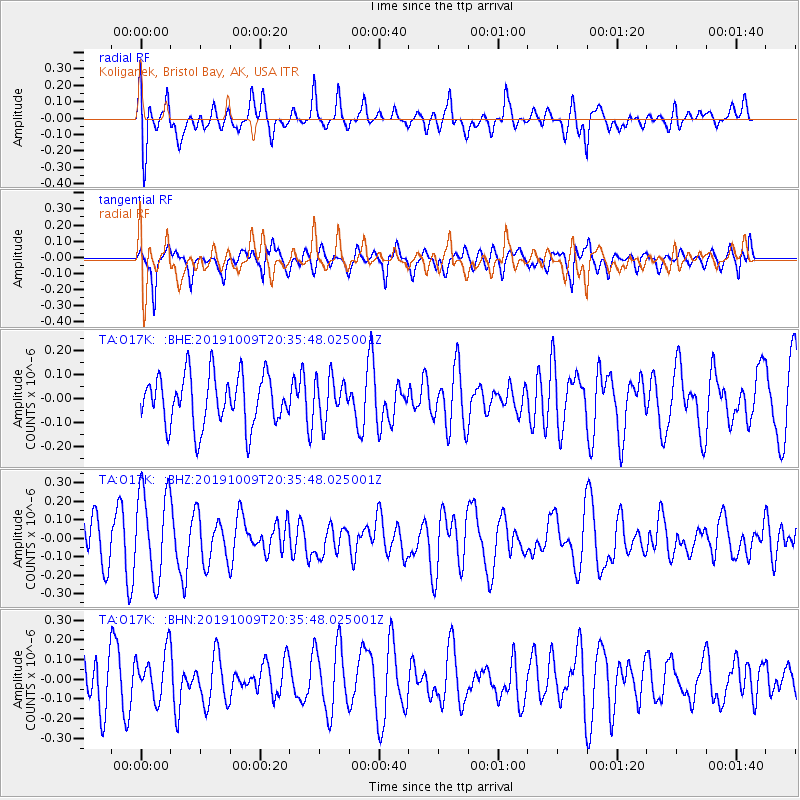
O17K Koliganek, Bristol Bay, AK, USA - Earthquake Result Viewer
*The percent match for this event was below the threshold and hence no stack was calculated.
| Earthquake location: |
East Of North Island, N.Z. |
| Earthquake latitude/longitude: |
-35.0/-179.3 |
| Earthquake time(UTC): |
2019/10/09 (282) 20:22:51 GMT |
| Earthquake Depth: |
10 km |
| Earthquake Magnitude: |
5.6 Mww |
| Earthquake Catalog/Contributor: |
NEIC PDE/us |
|
| Network: |
TA USArray Transportable Network (new EarthScope stations) |
| Station: |
O17K Koliganek, Bristol Bay, AK, USA |
| Lat/Lon: |
59.77 N/157.09 W |
| Elevation: |
156 m |
|
| Distance: |
96.2 deg |
| Az: |
11.103 deg |
| Baz: |
198.198 deg |
| Ray Param: |
$rayparam |
*The percent match for this event was below the threshold and hence was not used in the summary stack. |
|
| Radial Match: |
54.926567 % |
| Radial Bump: |
400 |
| Transverse Match: |
55.75676 % |
| Transverse Bump: |
326 |
| SOD ConfigId: |
19949251 |
| Insert Time: |
2019-10-23 20:28:48.181 +0000 |
| GWidth: |
2.5 |
| Max Bumps: |
400 |
| Tol: |
0.001 |
|
Signal To Noise
| Channel | StoN | STA | LTA |
| TA:O17K: :BHZ:20191009T20:35:48.025001Z | 1.9072742 | 2.4458797E-7 | 1.2823953E-7 |
| TA:O17K: :BHN:20191009T20:35:48.025001Z | 0.8537313 | 1.2199439E-7 | 1.4289553E-7 |
| TA:O17K: :BHE:20191009T20:35:48.025001Z | 0.805877 | 8.4652044E-8 | 1.0504338E-7 |
| Arrivals |
| Ps | |
| PpPs | |
| PsPs/PpSs | |


