You are here: Home > Network List > TA - USArray Transportable Network (new EarthScope stations) Stations List
> Station T11A Corn Creek, Alamo, NV, USA > Earthquake Result Viewer
T11A Corn Creek, Alamo, NV, USA - Earthquake Result Viewer

| Earthquake location: |
Andreanof Islands, Aleutian Is. |
| Earthquake latitude/longitude: |
51.9/-179.4 |
| Earthquake time(UTC): |
2008/04/15 (106) 22:59:51 GMT |
| Earthquake Depth: |
10 km |
| Earthquake Magnitude: |
6.1 MB, 6.4 MS, 6.4 MW, 6.4 MW |
| Earthquake Catalog/Contributor: |
WHDF/NEIC |
|
| Network: |
TA USArray Transportable Network (new EarthScope stations) |
| Station: |
T11A Corn Creek, Alamo, NV, USA |
| Lat/Lon: |
37.24 N/115.22 W |
| Elevation: |
1402 m |
|
| Distance: |
46.5 deg |
| Az: |
82.02 deg |
| Baz: |
309.677 deg |
| Ray Param: |
0.07061758 |
| Estimated Moho Depth: |
23.5 km |
| Estimated Crust Vp/Vs: |
1.70 |
| Assumed Crust Vp: |
6.276 km/s |
| Estimated Crust Vs: |
3.697 km/s |
| Estimated Crust Poisson's Ratio: |
0.23 |
|
| Radial Match: |
92.98236 % |
| Radial Bump: |
400 |
| Transverse Match: |
87.24793 % |
| Transverse Bump: |
400 |
| SOD ConfigId: |
2504 |
| Insert Time: |
2010-03-07 04:59:26.593 +0000 |
| GWidth: |
2.5 |
| Max Bumps: |
400 |
| Tol: |
0.001 |
|
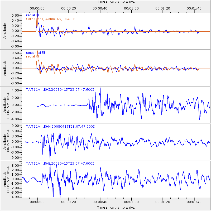
Signal To Noise
| Channel | StoN | STA | LTA |
| TA:T11A: :BHN:20080415T23:07:47.600Z | 16.171185 | 2.3946654E-6 | 1.4808225E-7 |
| TA:T11A: :BHE:20080415T23:07:47.600Z | 2.5320315 | 6.312921E-7 | 2.4932237E-7 |
| TA:T11A: :BHZ:20080415T23:07:47.600Z | 4.6199656 | 7.7898545E-7 | 1.6861283E-7 |
| Arrivals |
| Ps | 2.8 SECOND |
| PpPs | 9.5 SECOND |
| PsPs/PpSs | 12 SECOND |


