You are here: Home > Network List > TA - USArray Transportable Network (new EarthScope stations) Stations List
> Station T11A Corn Creek, Alamo, NV, USA > Earthquake Result Viewer
T11A Corn Creek, Alamo, NV, USA - Earthquake Result Viewer

| Earthquake location: |
Solomon Islands |
| Earthquake latitude/longitude: |
-10.5/161.3 |
| Earthquake time(UTC): |
2008/06/03 (155) 16:20:50 GMT |
| Earthquake Depth: |
84 km |
| Earthquake Magnitude: |
6.2 MB, 6.2 MW, 6.2 MW |
| Earthquake Catalog/Contributor: |
WHDF/NEIC |
|
| Network: |
TA USArray Transportable Network (new EarthScope stations) |
| Station: |
T11A Corn Creek, Alamo, NV, USA |
| Lat/Lon: |
37.24 N/115.22 W |
| Elevation: |
1402 m |
|
| Distance: |
91.2 deg |
| Az: |
52.476 deg |
| Baz: |
257.78 deg |
| Ray Param: |
0.041605357 |
| Estimated Moho Depth: |
21.0 km |
| Estimated Crust Vp/Vs: |
2.09 |
| Assumed Crust Vp: |
6.276 km/s |
| Estimated Crust Vs: |
2.999 km/s |
| Estimated Crust Poisson's Ratio: |
0.35 |
|
| Radial Match: |
89.6078 % |
| Radial Bump: |
400 |
| Transverse Match: |
82.33575 % |
| Transverse Bump: |
400 |
| SOD ConfigId: |
2504 |
| Insert Time: |
2010-03-07 04:59:34.802 +0000 |
| GWidth: |
2.5 |
| Max Bumps: |
400 |
| Tol: |
0.001 |
|
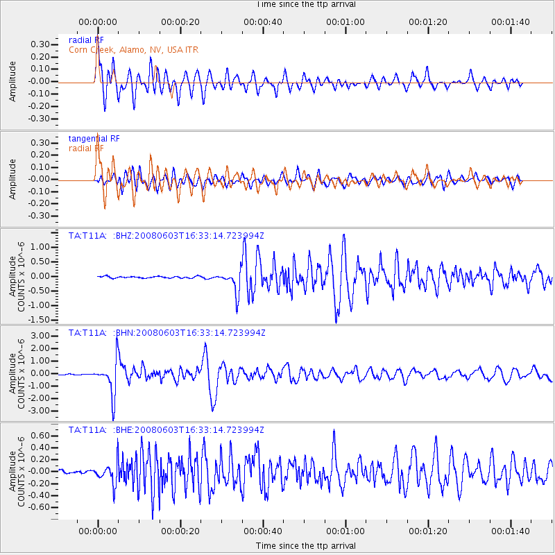
Signal To Noise
| Channel | StoN | STA | LTA |
| TA:T11A: :BHN:20080603T16:33:14.723994Z | 56.315624 | 1.4419695E-6 | 2.5605141E-8 |
| TA:T11A: :BHE:20080603T16:33:14.723994Z | 5.299317 | 1.7783755E-7 | 3.3558578E-8 |
| TA:T11A: :BHZ:20080603T16:33:14.723994Z | 14.451273 | 4.0982465E-7 | 2.835907E-8 |
| Arrivals |
| Ps | 3.7 SECOND |
| PpPs | 10 SECOND |
| PsPs/PpSs | 14 SECOND |


