You are here: Home > Network List > TA - USArray Transportable Network (new EarthScope stations) Stations List
> Station T11A Corn Creek, Alamo, NV, USA > Earthquake Result Viewer
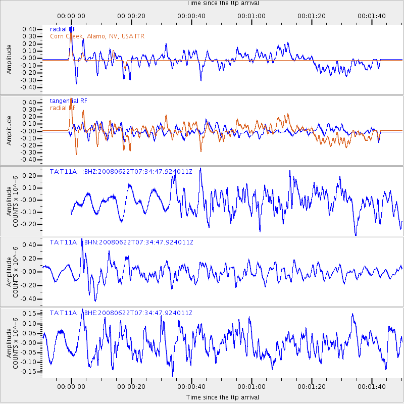
T11A Corn Creek, Alamo, NV, USA - Earthquake Result Viewer
*The percent match for this event was below the threshold and hence no stack was calculated.
| Earthquake location: |
Solomon Islands |
| Earthquake latitude/longitude: |
-8.9/157.8 |
| Earthquake time(UTC): |
2008/06/22 (174) 07:22:06 GMT |
| Earthquake Depth: |
10 km |
| Earthquake Magnitude: |
5.5 MB, 5.5 MS, 5.8 MW, 5.7 MW |
| Earthquake Catalog/Contributor: |
WHDF/NEIC |
|
| Network: |
TA USArray Transportable Network (new EarthScope stations) |
| Station: |
T11A Corn Creek, Alamo, NV, USA |
| Lat/Lon: |
37.24 N/115.22 W |
| Elevation: |
1402 m |
|
| Distance: |
92.9 deg |
| Az: |
52.936 deg |
| Baz: |
261.154 deg |
| Ray Param: |
$rayparam |
*The percent match for this event was below the threshold and hence was not used in the summary stack. |
|
| Radial Match: |
70.38632 % |
| Radial Bump: |
400 |
| Transverse Match: |
69.47009 % |
| Transverse Bump: |
400 |
| SOD ConfigId: |
2504 |
| Insert Time: |
2010-03-07 04:59:54.187 +0000 |
| GWidth: |
2.5 |
| Max Bumps: |
400 |
| Tol: |
0.001 |
|
Signal To Noise
| Channel | StoN | STA | LTA |
| TA:T11A: :BHN:20080622T07:34:47.924011Z | 2.6439934 | 1.8214014E-7 | 6.8888276E-8 |
| TA:T11A: :BHE:20080622T07:34:47.924011Z | 2.1826923 | 8.3493426E-8 | 3.8252495E-8 |
| TA:T11A: :BHZ:20080622T07:34:47.924011Z | 1.7218708 | 1.1231647E-7 | 6.522933E-8 |
| Arrivals |
| Ps | |
| PpPs | |
| PsPs/PpSs | |


