You are here: Home > Network List > TA - USArray Transportable Network (new EarthScope stations) Stations List
> Station T11A Corn Creek, Alamo, NV, USA > Earthquake Result Viewer
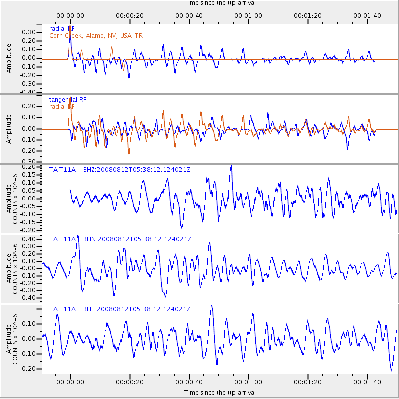
T11A Corn Creek, Alamo, NV, USA - Earthquake Result Viewer
*The percent match for this event was below the threshold and hence no stack was calculated.
| Earthquake location: |
Santa Cruz Islands |
| Earthquake latitude/longitude: |
-11.4/166.2 |
| Earthquake time(UTC): |
2008/08/12 (225) 05:25:57 GMT |
| Earthquake Depth: |
38 km |
| Earthquake Magnitude: |
5.9 MW, 5.4 MS, 5.2 MB, 5.8 MW |
| Earthquake Catalog/Contributor: |
WHDF/NEIC |
|
| Network: |
TA USArray Transportable Network (new EarthScope stations) |
| Station: |
T11A Corn Creek, Alamo, NV, USA |
| Lat/Lon: |
37.24 N/115.22 W |
| Elevation: |
1402 m |
|
| Distance: |
87.9 deg |
| Az: |
51.508 deg |
| Baz: |
254.06 deg |
| Ray Param: |
$rayparam |
*The percent match for this event was below the threshold and hence was not used in the summary stack. |
|
| Radial Match: |
64.10569 % |
| Radial Bump: |
400 |
| Transverse Match: |
55.57888 % |
| Transverse Bump: |
317 |
| SOD ConfigId: |
2504 |
| Insert Time: |
2010-03-07 05:00:04.663 +0000 |
| GWidth: |
2.5 |
| Max Bumps: |
400 |
| Tol: |
0.001 |
|
Signal To Noise
| Channel | StoN | STA | LTA |
| TA:T11A: :BHN:20080812T05:38:12.124021Z | 4.8012185 | 2.3153493E-7 | 4.8224205E-8 |
| TA:T11A: :BHE:20080812T05:38:12.124021Z | 0.5713862 | 2.9258205E-8 | 5.1205653E-8 |
| TA:T11A: :BHZ:20080812T05:38:12.124021Z | 1.6557779 | 6.531399E-8 | 3.9446103E-8 |
| Arrivals |
| Ps | |
| PpPs | |
| PsPs/PpSs | |


