You are here: Home > Network List > TA - USArray Transportable Network (new EarthScope stations) Stations List
> Station T11A Corn Creek, Alamo, NV, USA > Earthquake Result Viewer
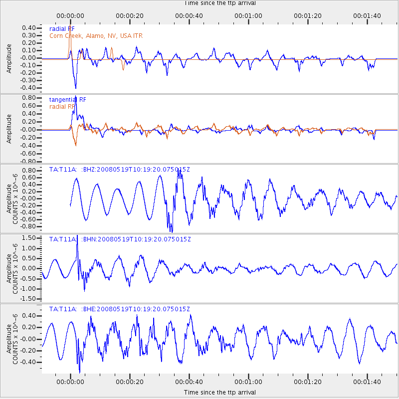
T11A Corn Creek, Alamo, NV, USA - Earthquake Result Viewer
*The percent match for this event was below the threshold and hence no stack was calculated.
| Earthquake location: |
E. Russia-N.E. China Border Reg. |
| Earthquake latitude/longitude: |
42.5/131.9 |
| Earthquake time(UTC): |
2008/05/19 (140) 10:08:36 GMT |
| Earthquake Depth: |
513 km |
| Earthquake Magnitude: |
5.7 MW, 5.4 MB, 5.6 MW |
| Earthquake Catalog/Contributor: |
WHDF/NEIC |
|
| Network: |
TA USArray Transportable Network (new EarthScope stations) |
| Station: |
T11A Corn Creek, Alamo, NV, USA |
| Lat/Lon: |
37.24 N/115.22 W |
| Elevation: |
1402 m |
|
| Distance: |
79.9 deg |
| Az: |
48.31 deg |
| Baz: |
316.214 deg |
| Ray Param: |
$rayparam |
*The percent match for this event was below the threshold and hence was not used in the summary stack. |
|
| Radial Match: |
67.75272 % |
| Radial Bump: |
400 |
| Transverse Match: |
77.07099 % |
| Transverse Bump: |
384 |
| SOD ConfigId: |
2504 |
| Insert Time: |
2010-03-07 05:00:12.801 +0000 |
| GWidth: |
2.5 |
| Max Bumps: |
400 |
| Tol: |
0.001 |
|
Signal To Noise
| Channel | StoN | STA | LTA |
| TA:T11A: :BHN:20080519T10:19:20.075015Z | 2.881845 | 5.3105083E-7 | 1.8427461E-7 |
| TA:T11A: :BHE:20080519T10:19:20.075015Z | 2.1677644 | 2.6780765E-7 | 1.2354094E-7 |
| TA:T11A: :BHZ:20080519T10:19:20.075015Z | 1.7131118 | 5.5915217E-7 | 3.263956E-7 |
| Arrivals |
| Ps | |
| PpPs | |
| PsPs/PpSs | |


