You are here: Home > Network List > TA - USArray Transportable Network (new EarthScope stations) Stations List
> Station T11A Corn Creek, Alamo, NV, USA > Earthquake Result Viewer
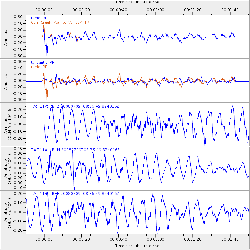
T11A Corn Creek, Alamo, NV, USA - Earthquake Result Viewer
*The percent match for this event was below the threshold and hence no stack was calculated.
| Earthquake location: |
Loyalty Islands |
| Earthquake latitude/longitude: |
-20.9/168.8 |
| Earthquake time(UTC): |
2008/07/09 (191) 08:24:16 GMT |
| Earthquake Depth: |
39 km |
| Earthquake Magnitude: |
5.6 MB, 4.9 MS, 5.4 MW |
| Earthquake Catalog/Contributor: |
WHDF/NEIC |
|
| Network: |
TA USArray Transportable Network (new EarthScope stations) |
| Station: |
T11A Corn Creek, Alamo, NV, USA |
| Lat/Lon: |
37.24 N/115.22 W |
| Elevation: |
1402 m |
|
| Distance: |
91.9 deg |
| Az: |
50.789 deg |
| Baz: |
245.185 deg |
| Ray Param: |
$rayparam |
*The percent match for this event was below the threshold and hence was not used in the summary stack. |
|
| Radial Match: |
75.61827 % |
| Radial Bump: |
400 |
| Transverse Match: |
49.935688 % |
| Transverse Bump: |
400 |
| SOD ConfigId: |
2504 |
| Insert Time: |
2010-03-07 05:00:17.131 +0000 |
| GWidth: |
2.5 |
| Max Bumps: |
400 |
| Tol: |
0.001 |
|
Signal To Noise
| Channel | StoN | STA | LTA |
| TA:T11A: :BHN:20080709T08:36:49.824016Z | 1.8401242 | 1.9255963E-7 | 1.0464491E-7 |
| TA:T11A: :BHE:20080709T08:36:49.824016Z | 1.4444915 | 1.5251679E-7 | 1.0558511E-7 |
| TA:T11A: :BHZ:20080709T08:36:49.824016Z | 0.6304192 | 1.044066E-7 | 1.6561457E-7 |
| Arrivals |
| Ps | |
| PpPs | |
| PsPs/PpSs | |


