You are here: Home > Network List > TA - USArray Transportable Network (new EarthScope stations) Stations List
> Station T11A Corn Creek, Alamo, NV, USA > Earthquake Result Viewer
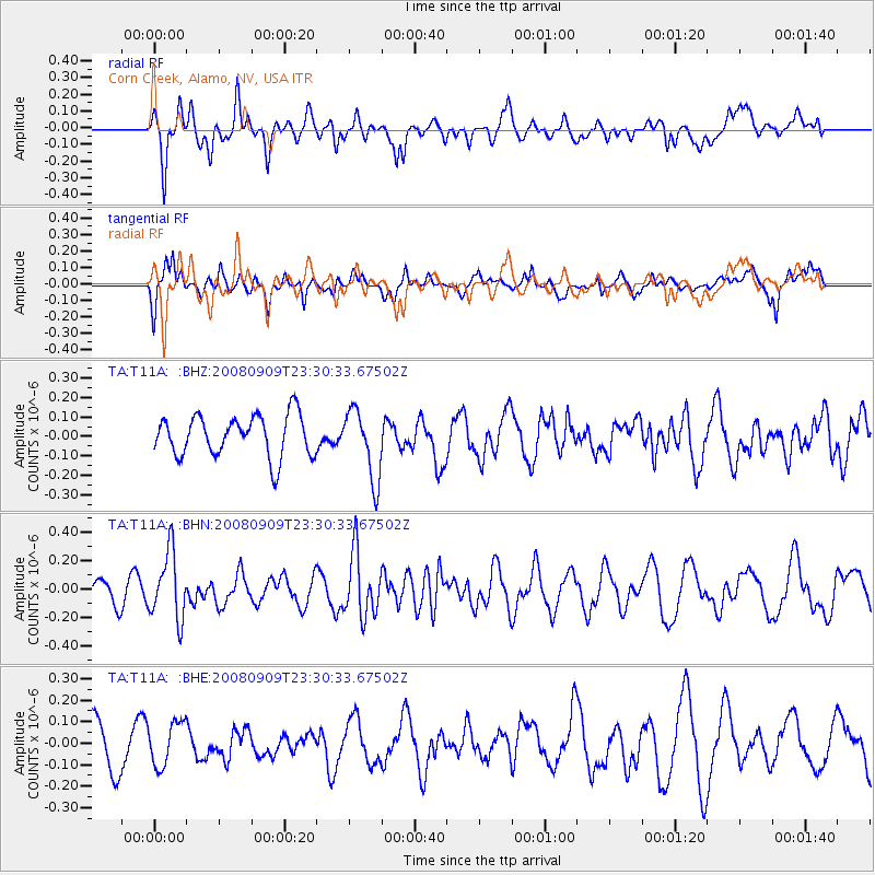
T11A Corn Creek, Alamo, NV, USA - Earthquake Result Viewer
*The percent match for this event was below the threshold and hence no stack was calculated.
| Earthquake location: |
Santa Cruz Islands |
| Earthquake latitude/longitude: |
-11.8/166.5 |
| Earthquake time(UTC): |
2008/09/09 (253) 23:18:26 GMT |
| Earthquake Depth: |
99 km |
| Earthquake Magnitude: |
5.6 MW, 5.4 MB, 5.6 MW |
| Earthquake Catalog/Contributor: |
WHDF/NEIC |
|
| Network: |
TA USArray Transportable Network (new EarthScope stations) |
| Station: |
T11A Corn Creek, Alamo, NV, USA |
| Lat/Lon: |
37.24 N/115.22 W |
| Elevation: |
1402 m |
|
| Distance: |
87.9 deg |
| Az: |
51.436 deg |
| Baz: |
253.603 deg |
| Ray Param: |
$rayparam |
*The percent match for this event was below the threshold and hence was not used in the summary stack. |
|
| Radial Match: |
65.80349 % |
| Radial Bump: |
400 |
| Transverse Match: |
62.029972 % |
| Transverse Bump: |
400 |
| SOD ConfigId: |
2560 |
| Insert Time: |
2010-03-07 05:00:25.713 +0000 |
| GWidth: |
2.5 |
| Max Bumps: |
400 |
| Tol: |
0.001 |
|
Signal To Noise
| Channel | StoN | STA | LTA |
| TA:T11A: :BHN:20080909T23:30:33.67502Z | 2.8535478 | 2.3367268E-7 | 8.188848E-8 |
| TA:T11A: :BHE:20080909T23:30:33.67502Z | 0.9807614 | 1.007254E-7 | 1.0270123E-7 |
| TA:T11A: :BHZ:20080909T23:30:33.67502Z | 1.7119915 | 1.8018561E-7 | 1.0524912E-7 |
| Arrivals |
| Ps | |
| PpPs | |
| PsPs/PpSs | |


