You are here: Home > Network List > AV - Alaska Volcano Observatory Stations List
> Station SPCR Ckakachatna River, Mount Spurr, Alaska > Earthquake Result Viewer
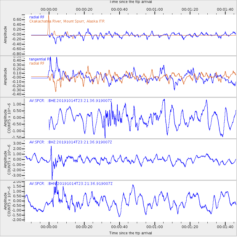
SPCR Ckakachatna River, Mount Spurr, Alaska - Earthquake Result Viewer
*The percent match for this event was below the threshold and hence no stack was calculated.
| Earthquake location: |
Kuril Islands |
| Earthquake latitude/longitude: |
44.6/146.7 |
| Earthquake time(UTC): |
2019/10/14 (287) 23:14:51 GMT |
| Earthquake Depth: |
93 km |
| Earthquake Magnitude: |
5.7 mb |
| Earthquake Catalog/Contributor: |
NEIC PDE/us |
|
| Network: |
AV Alaska Volcano Observatory |
| Station: |
SPCR Ckakachatna River, Mount Spurr, Alaska |
| Lat/Lon: |
61.20 N/152.21 W |
| Elevation: |
984 m |
|
| Distance: |
38.8 deg |
| Az: |
42.599 deg |
| Baz: |
273.381 deg |
| Ray Param: |
$rayparam |
*The percent match for this event was below the threshold and hence was not used in the summary stack. |
|
| Radial Match: |
53.254868 % |
| Radial Bump: |
400 |
| Transverse Match: |
54.232468 % |
| Transverse Bump: |
400 |
| SOD ConfigId: |
19951751 |
| Insert Time: |
2019-10-28 23:19:41.392 +0000 |
| GWidth: |
2.5 |
| Max Bumps: |
400 |
| Tol: |
0.001 |
|
Signal To Noise
| Channel | StoN | STA | LTA |
| AV:SPCR: :BHZ:20191014T23:21:36.919007Z | 2.6698558 | 1.2783258E-6 | 4.7879956E-7 |
| AV:SPCR: :BHN:20191014T23:21:36.919007Z | 1.1750323 | 8.700686E-7 | 7.404636E-7 |
| AV:SPCR: :BHE:20191014T23:21:36.919007Z | 1.1167499 | 5.350633E-7 | 4.791255E-7 |
| Arrivals |
| Ps | |
| PpPs | |
| PsPs/PpSs | |


