You are here: Home > Network List > CI - Caltech Regional Seismic Network Stations List
> Station MPM Manuel Prospect Mine, California, USA > Earthquake Result Viewer
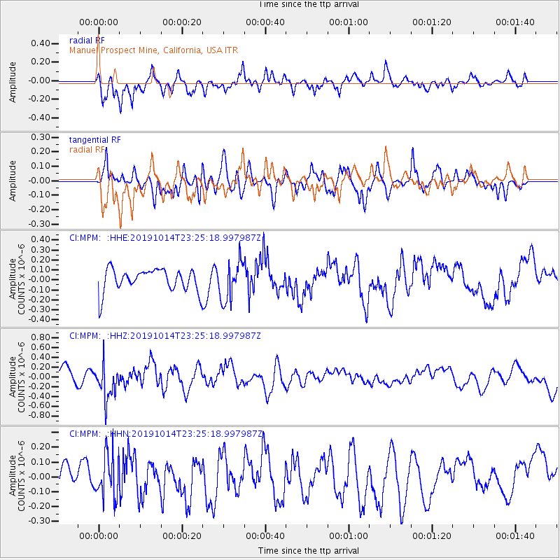
MPM Manuel Prospect Mine, California, USA - Earthquake Result Viewer
*The percent match for this event was below the threshold and hence no stack was calculated.
| Earthquake location: |
Kuril Islands |
| Earthquake latitude/longitude: |
44.6/146.7 |
| Earthquake time(UTC): |
2019/10/14 (287) 23:14:51 GMT |
| Earthquake Depth: |
93 km |
| Earthquake Magnitude: |
5.7 mb |
| Earthquake Catalog/Contributor: |
NEIC PDE/us |
|
| Network: |
CI Caltech Regional Seismic Network |
| Station: |
MPM Manuel Prospect Mine, California, USA |
| Lat/Lon: |
36.06 N/117.49 W |
| Elevation: |
185 m |
|
| Distance: |
69.4 deg |
| Az: |
59.44 deg |
| Baz: |
310.63 deg |
| Ray Param: |
$rayparam |
*The percent match for this event was below the threshold and hence was not used in the summary stack. |
|
| Radial Match: |
69.59656 % |
| Radial Bump: |
400 |
| Transverse Match: |
68.87399 % |
| Transverse Bump: |
400 |
| SOD ConfigId: |
19951751 |
| Insert Time: |
2019-10-28 23:20:43.826 +0000 |
| GWidth: |
2.5 |
| Max Bumps: |
400 |
| Tol: |
0.001 |
|
Signal To Noise
| Channel | StoN | STA | LTA |
| CI:MPM: :HHZ:20191014T23:25:18.997987Z | 2.6019795 | 3.5813548E-7 | 1.3763962E-7 |
| CI:MPM: :HHN:20191014T23:25:18.997987Z | 1.4495171 | 1.4807635E-7 | 1.02155646E-7 |
| CI:MPM: :HHE:20191014T23:25:18.997987Z | 1.7441033 | 1.9918775E-7 | 1.14206394E-7 |
| Arrivals |
| Ps | |
| PpPs | |
| PsPs/PpSs | |


