You are here: Home > Network List > TA - USArray Transportable Network (new EarthScope stations) Stations List
> Station L22A Ellis Ranch, Medicine Bow, WY, USA > Earthquake Result Viewer
L22A Ellis Ranch, Medicine Bow, WY, USA - Earthquake Result Viewer
| Earthquake location: |
Near S. Coast Of Honshu, Japan |
| Earthquake latitude/longitude: |
33.2/137.9 |
| Earthquake time(UTC): |
2009/08/09 (221) 10:55:55 GMT |
| Earthquake Depth: |
297 km |
| Earthquake Magnitude: |
6.5 MB, 7.1 MW, 7.1 MW |
| Earthquake Catalog/Contributor: |
WHDF/NEIC |
|
| Network: |
TA USArray Transportable Network (new EarthScope stations) |
| Station: |
L22A Ellis Ranch, Medicine Bow, WY, USA |
| Lat/Lon: |
42.03 N/106.43 W |
| Elevation: |
2012 m |
|
| Distance: |
84.7 deg |
| Az: |
42.428 deg |
| Baz: |
310.576 deg |
| Ray Param: |
0.044565048 |
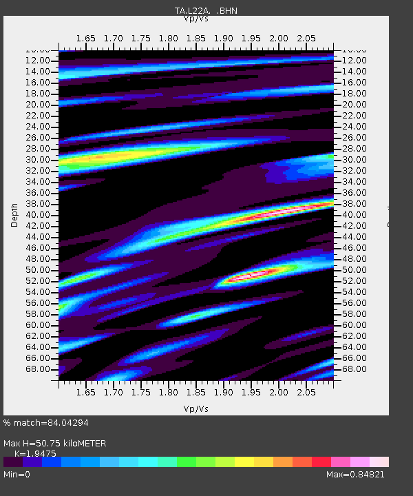
| Estimated Moho Depth: |
50.75 km |
| Estimated Crust Vp/Vs: |
1.95 |
| Assumed Crust Vp: |
6.178 km/s |
| Estimated Crust Vs: |
3.172 km/s |
| Estimated Crust Poisson's Ratio: |
0.32 |
|
| Radial Match: |
84.04294 % |
| Radial Bump: |
400 |
| Transverse Match: |
67.86607 % |
| Transverse Bump: |
400 |
| SOD ConfigId: |
2622 |
| Insert Time: |
2010-03-07 05:00:47.711 +0000 |
| GWidth: |
2.5 |
| Max Bumps: |
400 |
| Tol: |
0.001 |
|

Signal To Noise
| Channel | StoN | STA | LTA |
| TA:L22A: :BHN:20090809T11:07:25.024001Z | 76.12179 | 7.4654267E-6 | 9.807214E-8 |
| TA:L22A: :BHE:20090809T11:07:25.024001Z | 31.51268 | 2.9592825E-6 | 9.3907666E-8 |
| TA:L22A: :BHZ:20090809T11:07:25.024001Z | 14.254301 | 2.598509E-6 | 1.8229649E-7 |
| Arrivals |
| Ps | 7.9 SECOND |
| PpPs | 24 SECOND |
| PsPs/PpSs | 32 SECOND |


