You are here: Home > Network List > TA - USArray Transportable Network (new EarthScope stations) Stations List
> Station L22A Ellis Ranch, Medicine Bow, WY, USA > Earthquake Result Viewer
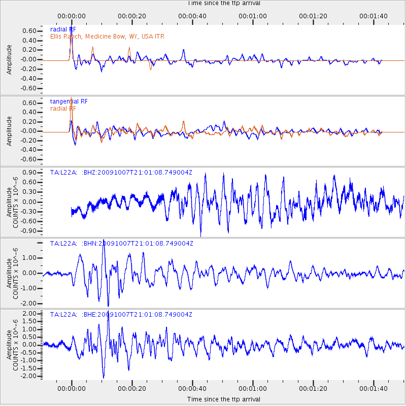
L22A Ellis Ranch, Medicine Bow, WY, USA - Earthquake Result Viewer
| Earthquake location: |
East Of Severnaya Zemlya |
| Earthquake latitude/longitude: |
81.6/119.5 |
| Earthquake time(UTC): |
2009/10/07 (280) 20:52:13 GMT |
| Earthquake Depth: |
8.0 km |
| Earthquake Magnitude: |
5.7 MB, 5.1 MS, 5.8 MW, 5.8 MW |
| Earthquake Catalog/Contributor: |
WHDF/NEIC |
|
| Network: |
TA USArray Transportable Network (new EarthScope stations) |
| Station: |
L22A Ellis Ranch, Medicine Bow, WY, USA |
| Lat/Lon: |
42.03 N/106.43 W |
| Elevation: |
2012 m |
|
| Distance: |
54.3 deg |
| Az: |
41.258 deg |
| Baz: |
352.496 deg |
| Ray Param: |
0.06553034 |
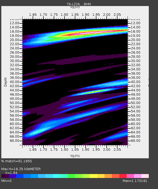
| Estimated Moho Depth: |
16.25 km |
| Estimated Crust Vp/Vs: |
1.94 |
| Assumed Crust Vp: |
6.178 km/s |
| Estimated Crust Vs: |
3.185 km/s |
| Estimated Crust Poisson's Ratio: |
0.32 |
|
| Radial Match: |
81.1655 % |
| Radial Bump: |
400 |
| Transverse Match: |
63.775917 % |
| Transverse Bump: |
400 |
| SOD ConfigId: |
2622 |
| Insert Time: |
2010-03-07 05:00:55.639 +0000 |
| GWidth: |
2.5 |
| Max Bumps: |
400 |
| Tol: |
0.001 |
|
Signal To Noise
| Channel | StoN | STA | LTA |
| TA:L22A: :BHN:20091007T21:01:08.749004Z | 5.3203125 | 6.858377E-7 | 1.2890929E-7 |
| TA:L22A: :BHE:20091007T21:01:08.749004Z | 3.6085694 | 4.620257E-7 | 1.280357E-7 |
| TA:L22A: :BHZ:20091007T21:01:08.749004Z | 1.648224 | 2.940563E-7 | 1.7840797E-7 |
| Arrivals |
| Ps | 2.6 SECOND |
| PpPs | 7.4 SECOND |
| PsPs/PpSs | 10.0 SECOND |


