You are here: Home > Network List > TA - USArray Transportable Network (new EarthScope stations) Stations List
> Station L22A Ellis Ranch, Medicine Bow, WY, USA > Earthquake Result Viewer
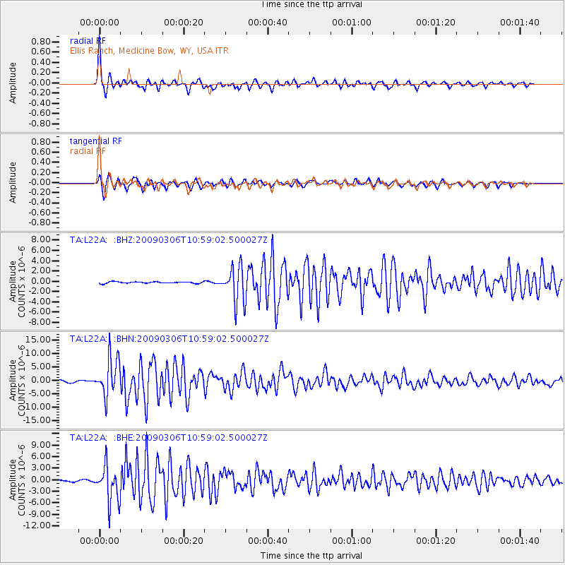
L22A Ellis Ranch, Medicine Bow, WY, USA - Earthquake Result Viewer
| Earthquake location: |
North Of Svalbard |
| Earthquake latitude/longitude: |
80.3/-1.9 |
| Earthquake time(UTC): |
2009/03/06 (065) 10:50:29 GMT |
| Earthquake Depth: |
9.0 km |
| Earthquake Magnitude: |
6.6 MB, 6.5 MS, 6.5 MW, 6.4 MW |
| Earthquake Catalog/Contributor: |
WHDF/NEIC |
|
| Network: |
TA USArray Transportable Network (new EarthScope stations) |
| Station: |
L22A Ellis Ranch, Medicine Bow, WY, USA |
| Lat/Lon: |
42.03 N/106.43 W |
| Elevation: |
2012 m |
|
| Distance: |
51.3 deg |
| Az: |
292.435 deg |
| Baz: |
12.116 deg |
| Ray Param: |
0.06752422 |
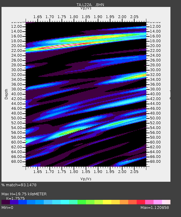
| Estimated Moho Depth: |
19.75 km |
| Estimated Crust Vp/Vs: |
1.76 |
| Assumed Crust Vp: |
6.178 km/s |
| Estimated Crust Vs: |
3.515 km/s |
| Estimated Crust Poisson's Ratio: |
0.26 |
|
| Radial Match: |
93.1478 % |
| Radial Bump: |
400 |
| Transverse Match: |
89.795784 % |
| Transverse Bump: |
400 |
| SOD ConfigId: |
2658 |
| Insert Time: |
2010-03-07 05:01:03.062 +0000 |
| GWidth: |
2.5 |
| Max Bumps: |
400 |
| Tol: |
0.001 |
|
Signal To Noise
| Channel | StoN | STA | LTA |
| TA:L22A: :BHN:20090306T10:59:02.500027Z | 23.183416 | 7.285261E-6 | 3.142445E-7 |
| TA:L22A: :BHE:20090306T10:59:02.500027Z | 21.598988 | 4.8053457E-6 | 2.2248012E-7 |
| TA:L22A: :BHZ:20090306T10:59:02.500027Z | 23.80791 | 3.5852531E-6 | 1.5059084E-7 |
| Arrivals |
| Ps | 2.6 SECOND |
| PpPs | 8.4 SECOND |
| PsPs/PpSs | 11 SECOND |


