You are here: Home > Network List > TA - USArray Transportable Network (new EarthScope stations) Stations List
> Station L22A Ellis Ranch, Medicine Bow, WY, USA > Earthquake Result Viewer
L22A Ellis Ranch, Medicine Bow, WY, USA - Earthquake Result Viewer
| Earthquake location: |
South Of Fiji Islands |
| Earthquake latitude/longitude: |
-26.0/-177.5 |
| Earthquake time(UTC): |
2007/12/09 (343) 07:28:20 GMT |
| Earthquake Depth: |
152 km |
| Earthquake Magnitude: |
7.0 MB, 7.8 MW, 7.7 MW |
| Earthquake Catalog/Contributor: |
WHDF/NEIC |
|
| Network: |
TA USArray Transportable Network (new EarthScope stations) |
| Station: |
L22A Ellis Ranch, Medicine Bow, WY, USA |
| Lat/Lon: |
42.03 N/106.43 W |
| Elevation: |
2012 m |
|
| Distance: |
94.2 deg |
| Az: |
44.965 deg |
| Baz: |
238.612 deg |
| Ray Param: |
0.04099165 |
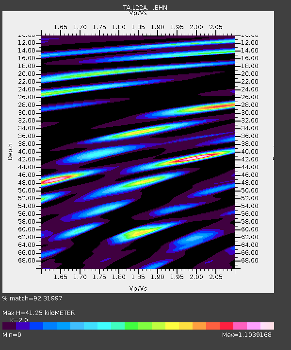
| Estimated Moho Depth: |
41.25 km |
| Estimated Crust Vp/Vs: |
2.00 |
| Assumed Crust Vp: |
6.178 km/s |
| Estimated Crust Vs: |
3.089 km/s |
| Estimated Crust Poisson's Ratio: |
0.33 |
|
| Radial Match: |
92.31997 % |
| Radial Bump: |
400 |
| Transverse Match: |
88.06362 % |
| Transverse Bump: |
400 |
| SOD ConfigId: |
2564 |
| Insert Time: |
2010-03-07 05:01:04.838 +0000 |
| GWidth: |
2.5 |
| Max Bumps: |
400 |
| Tol: |
0.001 |
|
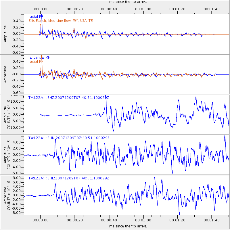
Signal To Noise
| Channel | StoN | STA | LTA |
| TA:L22A: :BHN:20071209T07:40:51.100029Z | 1.3001583 | 1.9940741E-7 | 1.5337166E-7 |
| TA:L22A: :BHE:20071209T07:40:51.100029Z | 1.3792492 | 2.2982236E-7 | 1.666286E-7 |
| TA:L22A: :BHZ:20071209T07:40:51.100029Z | 3.2819612 | 7.5010456E-7 | 2.2855374E-7 |
| Arrivals |
| Ps | 6.8 SECOND |
| PpPs | 20 SECOND |
| PsPs/PpSs | 26 SECOND |


