You are here: Home > Network List > TA - USArray Transportable Network (new EarthScope stations) Stations List
> Station G31M Satah River, YT, CAN > Earthquake Result Viewer
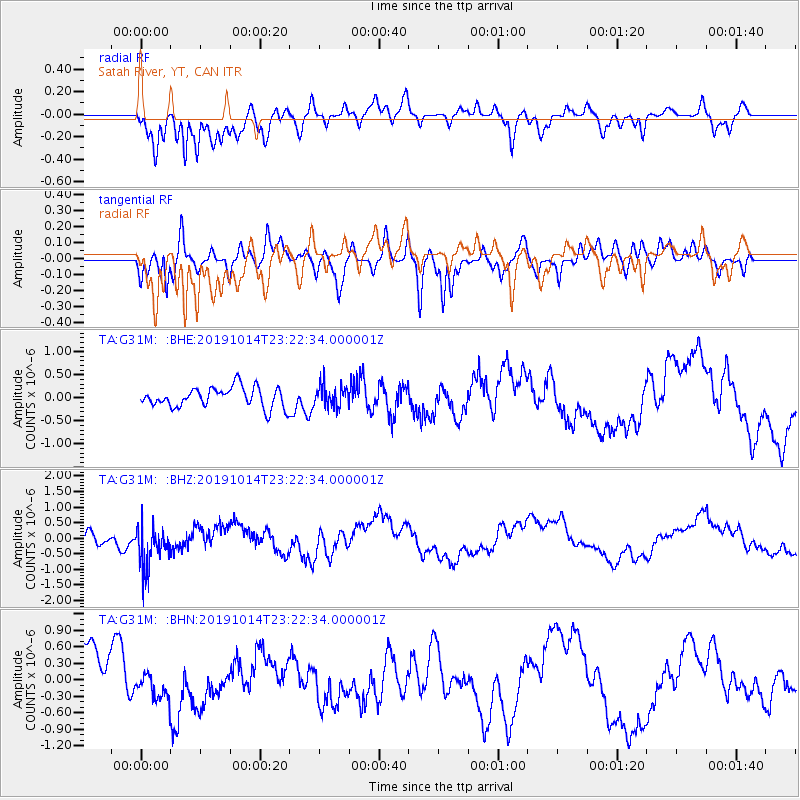
G31M Satah River, YT, CAN - Earthquake Result Viewer
*The percent match for this event was below the threshold and hence no stack was calculated.
| Earthquake location: |
Kuril Islands |
| Earthquake latitude/longitude: |
44.6/146.7 |
| Earthquake time(UTC): |
2019/10/14 (287) 23:14:51 GMT |
| Earthquake Depth: |
93 km |
| Earthquake Magnitude: |
5.7 mb |
| Earthquake Catalog/Contributor: |
NEIC PDE/us |
|
| Network: |
TA USArray Transportable Network (new EarthScope stations) |
| Station: |
G31M Satah River, YT, CAN |
| Lat/Lon: |
66.92 N/134.27 W |
| Elevation: |
61 m |
|
| Distance: |
45.8 deg |
| Az: |
32.656 deg |
| Baz: |
282.161 deg |
| Ray Param: |
$rayparam |
*The percent match for this event was below the threshold and hence was not used in the summary stack. |
|
| Radial Match: |
82.14863 % |
| Radial Bump: |
400 |
| Transverse Match: |
56.50711 % |
| Transverse Bump: |
400 |
| SOD ConfigId: |
19951751 |
| Insert Time: |
2019-10-28 23:25:50.462 +0000 |
| GWidth: |
2.5 |
| Max Bumps: |
400 |
| Tol: |
0.001 |
|
Signal To Noise
| Channel | StoN | STA | LTA |
| TA:G31M: :BHZ:20191014T23:22:34.000001Z | 2.46837 | 6.70809E-7 | 2.7176193E-7 |
| TA:G31M: :BHN:20191014T23:22:34.000001Z | 0.6110628 | 2.4058528E-7 | 3.937161E-7 |
| TA:G31M: :BHE:20191014T23:22:34.000001Z | 1.0616783 | 2.302192E-7 | 2.168446E-7 |
| Arrivals |
| Ps | |
| PpPs | |
| PsPs/PpSs | |


