You are here: Home > Network List > TA - USArray Transportable Network (new EarthScope stations) Stations List
> Station I30M Mount Dempster, Yukon, CAN > Earthquake Result Viewer
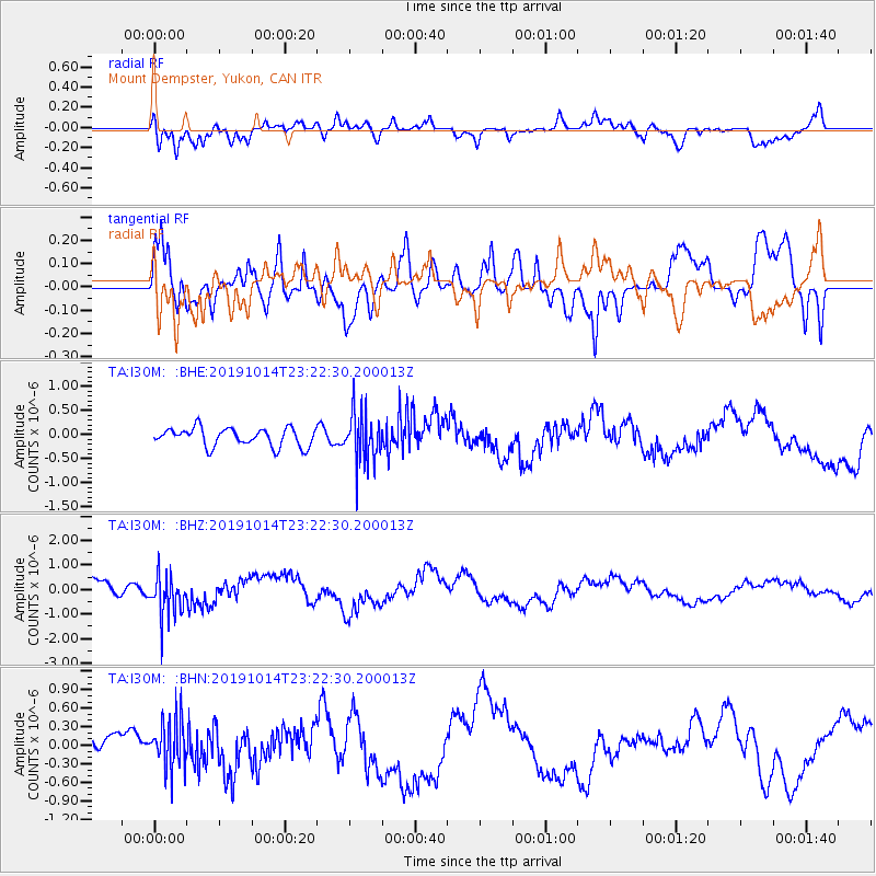
I30M Mount Dempster, Yukon, CAN - Earthquake Result Viewer
*The percent match for this event was below the threshold and hence no stack was calculated.
| Earthquake location: |
Kuril Islands |
| Earthquake latitude/longitude: |
44.6/146.7 |
| Earthquake time(UTC): |
2019/10/14 (287) 23:14:51 GMT |
| Earthquake Depth: |
93 km |
| Earthquake Magnitude: |
5.7 mb |
| Earthquake Catalog/Contributor: |
NEIC PDE/us |
|
| Network: |
TA USArray Transportable Network (new EarthScope stations) |
| Station: |
I30M Mount Dempster, Yukon, CAN |
| Lat/Lon: |
65.22 N/136.38 W |
| Elevation: |
1399 m |
|
| Distance: |
45.3 deg |
| Az: |
35.246 deg |
| Baz: |
282.05 deg |
| Ray Param: |
$rayparam |
*The percent match for this event was below the threshold and hence was not used in the summary stack. |
|
| Radial Match: |
85.26374 % |
| Radial Bump: |
400 |
| Transverse Match: |
68.66671 % |
| Transverse Bump: |
400 |
| SOD ConfigId: |
19951751 |
| Insert Time: |
2019-10-28 23:25:55.673 +0000 |
| GWidth: |
2.5 |
| Max Bumps: |
400 |
| Tol: |
0.001 |
|
Signal To Noise
| Channel | StoN | STA | LTA |
| TA:I30M: :BHZ:20191014T23:22:30.200013Z | 3.4234068 | 8.7061073E-7 | 2.543112E-7 |
| TA:I30M: :BHN:20191014T23:22:30.200013Z | 1.5461953 | 3.8998442E-7 | 2.5222198E-7 |
| TA:I30M: :BHE:20191014T23:22:30.200013Z | 2.7723677 | 5.18088E-7 | 1.8687562E-7 |
| Arrivals |
| Ps | |
| PpPs | |
| PsPs/PpSs | |


