You are here: Home > Network List > US - United States National Seismic Network Stations List
> Station AGMN Agassiz National Wildlife Refuge, Minnesota, USA > Earthquake Result Viewer
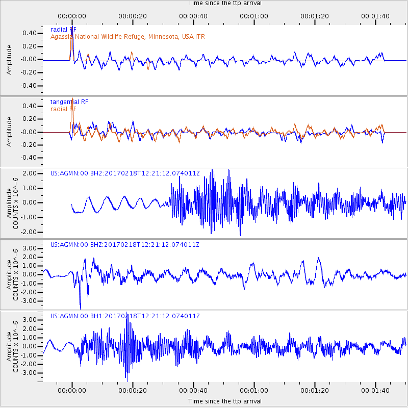
AGMN Agassiz National Wildlife Refuge, Minnesota, USA - Earthquake Result Viewer
*The percent match for this event was below the threshold and hence no stack was calculated.
| Earthquake location: |
Jujuy Province, Argentina |
| Earthquake latitude/longitude: |
-23.9/-66.7 |
| Earthquake time(UTC): |
2017/02/18 (049) 12:10:15 GMT |
| Earthquake Depth: |
201 km |
| Earthquake Magnitude: |
6.3 Mww |
| Earthquake Catalog/Contributor: |
NEIC PDE/us |
|
| Network: |
US United States National Seismic Network |
| Station: |
AGMN Agassiz National Wildlife Refuge, Minnesota, USA |
| Lat/Lon: |
48.30 N/95.86 W |
| Elevation: |
351 m |
|
| Distance: |
76.5 deg |
| Az: |
340.443 deg |
| Baz: |
152.693 deg |
| Ray Param: |
$rayparam |
*The percent match for this event was below the threshold and hence was not used in the summary stack. |
|
| Radial Match: |
63.046387 % |
| Radial Bump: |
372 |
| Transverse Match: |
65.50908 % |
| Transverse Bump: |
400 |
| SOD ConfigId: |
1992691 |
| Insert Time: |
2017-03-04 12:16:39.987 +0000 |
| GWidth: |
2.5 |
| Max Bumps: |
400 |
| Tol: |
0.001 |
|
Signal To Noise
| Channel | StoN | STA | LTA |
| US:AGMN:00:BHZ:20170218T12:21:12.074011Z | 3.2157013 | 1.0984334E-6 | 3.4158438E-7 |
| US:AGMN:00:BH1:20170218T12:21:12.074011Z | 1.9644921 | 7.509762E-7 | 3.82275E-7 |
| US:AGMN:00:BH2:20170218T12:21:12.074011Z | 1.3847573 | 4.898357E-7 | 3.5373395E-7 |
| Arrivals |
| Ps | |
| PpPs | |
| PsPs/PpSs | |


