You are here: Home > Network List > US - United States National Seismic Network Stations List
> Station AMTX Amarillo, Texas, USA > Earthquake Result Viewer
AMTX Amarillo, Texas, USA - Earthquake Result Viewer
*The percent match for this event was below the threshold and hence no stack was calculated.
| Earthquake location: |
Kuril Islands |
| Earthquake latitude/longitude: |
44.6/146.7 |
| Earthquake time(UTC): |
2019/10/14 (287) 23:14:51 GMT |
| Earthquake Depth: |
93 km |
| Earthquake Magnitude: |
5.7 mb |
| Earthquake Catalog/Contributor: |
NEIC PDE/us |
|
| Network: |
US United States National Seismic Network |
| Station: |
AMTX Amarillo, Texas, USA |
| Lat/Lon: |
34.53 N/101.41 W |
| Elevation: |
1010 m |
|
| Distance: |
79.9 deg |
| Az: |
51.083 deg |
| Baz: |
317.698 deg |
| Ray Param: |
$rayparam |
*The percent match for this event was below the threshold and hence was not used in the summary stack. |
|
| Radial Match: |
49.74336 % |
| Radial Bump: |
400 |
| Transverse Match: |
54.31843 % |
| Transverse Bump: |
400 |
| SOD ConfigId: |
19951751 |
| Insert Time: |
2019-10-28 23:26:57.623 +0000 |
| GWidth: |
2.5 |
| Max Bumps: |
400 |
| Tol: |
0.001 |
|
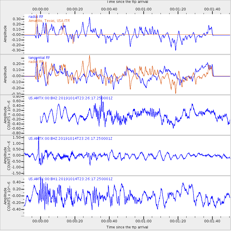
Signal To Noise
| Channel | StoN | STA | LTA |
| US:AMTX:00:BHZ:20191014T23:26:17.250001Z | 4.2109447 | 4.5744372E-7 | 1.0863209E-7 |
| US:AMTX:00:BH1:20191014T23:26:17.250001Z | 1.3619438 | 2.3717942E-7 | 1.7414771E-7 |
| US:AMTX:00:BH2:20191014T23:26:17.250001Z | 1.6803367 | 3.4368063E-7 | 2.045308E-7 |
| Arrivals |
| Ps | |
| PpPs | |
| PsPs/PpSs | |


