You are here: Home > Network List > US - United States National Seismic Network Stations List
> Station EGMT Eagleton, Montana, USA > Earthquake Result Viewer
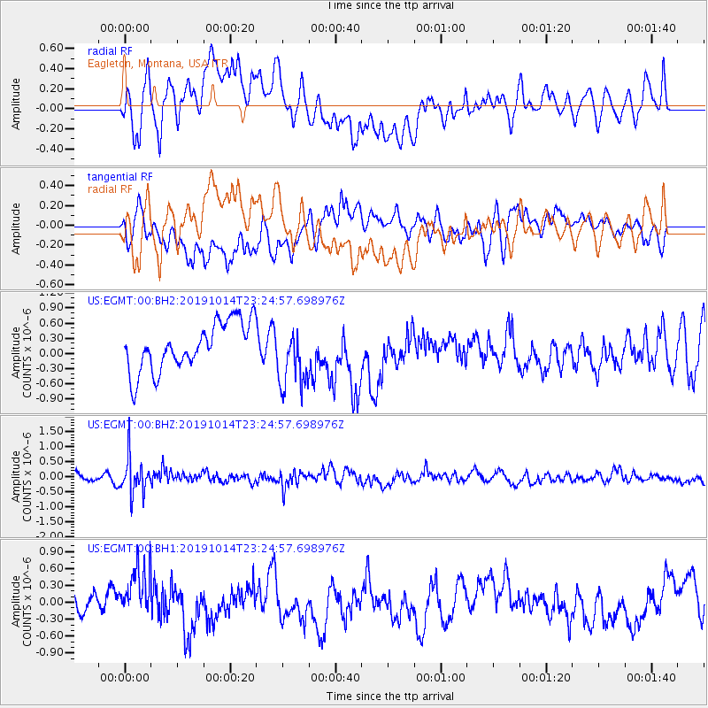
EGMT Eagleton, Montana, USA - Earthquake Result Viewer
*The percent match for this event was below the threshold and hence no stack was calculated.
| Earthquake location: |
Kuril Islands |
| Earthquake latitude/longitude: |
44.6/146.7 |
| Earthquake time(UTC): |
2019/10/14 (287) 23:14:51 GMT |
| Earthquake Depth: |
93 km |
| Earthquake Magnitude: |
5.7 mb |
| Earthquake Catalog/Contributor: |
NEIC PDE/us |
|
| Network: |
US United States National Seismic Network |
| Station: |
EGMT Eagleton, Montana, USA |
| Lat/Lon: |
48.02 N/109.75 W |
| Elevation: |
1055 m |
|
| Distance: |
66.0 deg |
| Az: |
45.585 deg |
| Baz: |
310.545 deg |
| Ray Param: |
$rayparam |
*The percent match for this event was below the threshold and hence was not used in the summary stack. |
|
| Radial Match: |
52.550774 % |
| Radial Bump: |
400 |
| Transverse Match: |
39.658722 % |
| Transverse Bump: |
400 |
| SOD ConfigId: |
19951751 |
| Insert Time: |
2019-10-28 23:27:03.089 +0000 |
| GWidth: |
2.5 |
| Max Bumps: |
400 |
| Tol: |
0.001 |
|
Signal To Noise
| Channel | StoN | STA | LTA |
| US:EGMT:00:BHZ:20191014T23:24:57.698976Z | 4.109383 | 6.016905E-7 | 1.464187E-7 |
| US:EGMT:00:BH1:20191014T23:24:57.698976Z | 1.5389836 | 4.4657827E-7 | 2.901774E-7 |
| US:EGMT:00:BH2:20191014T23:24:57.698976Z | 1.2963296 | 6.1438453E-7 | 4.739416E-7 |
| Arrivals |
| Ps | |
| PpPs | |
| PsPs/PpSs | |


