You are here: Home > Network List > TA - USArray Transportable Network (new EarthScope stations) Stations List
> Station L22A Ellis Ranch, Medicine Bow, WY, USA > Earthquake Result Viewer
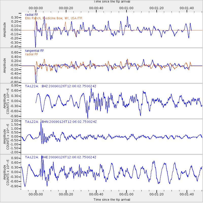
L22A Ellis Ranch, Medicine Bow, WY, USA - Earthquake Result Viewer
*The percent match for this event was below the threshold and hence no stack was calculated.
| Earthquake location: |
Fiji Islands Region |
| Earthquake latitude/longitude: |
-17.8/-178.6 |
| Earthquake time(UTC): |
2009/01/26 (026) 11:54:39 GMT |
| Earthquake Depth: |
580 km |
| Earthquake Magnitude: |
5.5 MB, 5.8 MW, 5.8 MW |
| Earthquake Catalog/Contributor: |
WHDF/NEIC |
|
| Network: |
TA USArray Transportable Network (new EarthScope stations) |
| Station: |
L22A Ellis Ranch, Medicine Bow, WY, USA |
| Lat/Lon: |
42.03 N/106.43 W |
| Elevation: |
2012 m |
|
| Distance: |
89.1 deg |
| Az: |
45.175 deg |
| Baz: |
245.097 deg |
| Ray Param: |
$rayparam |
*The percent match for this event was below the threshold and hence was not used in the summary stack. |
|
| Radial Match: |
56.53889 % |
| Radial Bump: |
400 |
| Transverse Match: |
61.717834 % |
| Transverse Bump: |
386 |
| SOD ConfigId: |
2658 |
| Insert Time: |
2010-03-07 05:02:12.318 +0000 |
| GWidth: |
2.5 |
| Max Bumps: |
400 |
| Tol: |
0.001 |
|
Signal To Noise
| Channel | StoN | STA | LTA |
| TA:L22A: :BHN:20090126T12:06:02.750024Z | 1.8750966 | 5.7163203E-7 | 3.048547E-7 |
| TA:L22A: :BHE:20090126T12:06:02.750024Z | 1.2465526 | 3.8423036E-7 | 3.0823438E-7 |
| TA:L22A: :BHZ:20090126T12:06:02.750024Z | 1.5310458 | 4.090906E-7 | 2.6719684E-7 |
| Arrivals |
| Ps | |
| PpPs | |
| PsPs/PpSs | |


