You are here: Home > Network List > IU - Global Seismograph Network (GSN - IRIS/USGS) Stations List
> Station MAKZ Makanchi, Kazakhstan > Earthquake Result Viewer
MAKZ Makanchi, Kazakhstan - Earthquake Result Viewer
| Earthquake location: |
Mindanao, Philippines |
| Earthquake latitude/longitude: |
6.7/125.0 |
| Earthquake time(UTC): |
2019/10/16 (289) 11:37:06 GMT |
| Earthquake Depth: |
14 km |
| Earthquake Magnitude: |
6.4 mww |
| Earthquake Catalog/Contributor: |
NEIC PDE/us |
|
| Network: |
IU Global Seismograph Network (GSN - IRIS/USGS) |
| Station: |
MAKZ Makanchi, Kazakhstan |
| Lat/Lon: |
46.81 N/81.98 E |
| Elevation: |
600 m |
|
| Distance: |
54.3 deg |
| Az: |
324.764 deg |
| Baz: |
123.462 deg |
| Ray Param: |
0.06550609 |
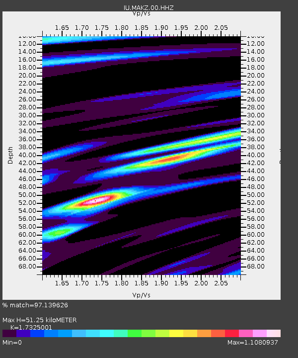
| Estimated Moho Depth: |
51.25 km |
| Estimated Crust Vp/Vs: |
1.73 |
| Assumed Crust Vp: |
6.571 km/s |
| Estimated Crust Vs: |
3.793 km/s |
| Estimated Crust Poisson's Ratio: |
0.25 |
|
| Radial Match: |
97.139626 % |
| Radial Bump: |
317 |
| Transverse Match: |
87.048904 % |
| Transverse Bump: |
400 |
| SOD ConfigId: |
19951751 |
| Insert Time: |
2019-10-30 11:42:37.526 +0000 |
| GWidth: |
2.5 |
| Max Bumps: |
400 |
| Tol: |
0.001 |
|

Signal To Noise
| Channel | StoN | STA | LTA |
| IU:MAKZ:00:HHZ:20191016T11:46:00.908Z | 29.965073 | 1.1394483E-6 | 3.8025878E-8 |
| IU:MAKZ:00:HH1:20191016T11:46:00.908Z | 7.81815 | 2.2949841E-7 | 2.9354567E-8 |
| IU:MAKZ:00:HH2:20191016T11:46:00.908Z | 14.444449 | 4.5721328E-7 | 3.1653215E-8 |
| Arrivals |
| Ps | 6.0 SECOND |
| PpPs | 20 SECOND |
| PsPs/PpSs | 26 SECOND |


