You are here: Home > Network List > MM - Myanmar National Seismic Network Stations List
> Station NGU Ngaung U, Myanmar > Earthquake Result Viewer
NGU Ngaung U, Myanmar - Earthquake Result Viewer
| Earthquake location: |
Mindanao, Philippines |
| Earthquake latitude/longitude: |
6.7/125.0 |
| Earthquake time(UTC): |
2019/10/16 (289) 11:37:06 GMT |
| Earthquake Depth: |
14 km |
| Earthquake Magnitude: |
6.4 mww |
| Earthquake Catalog/Contributor: |
NEIC PDE/us |
|
| Network: |
MM Myanmar National Seismic Network |
| Station: |
NGU Ngaung U, Myanmar |
| Lat/Lon: |
21.21 N/94.92 E |
| Elevation: |
70 m |
|
| Distance: |
32.5 deg |
| Az: |
299.385 deg |
| Baz: |
111.953 deg |
| Ray Param: |
0.07862979 |
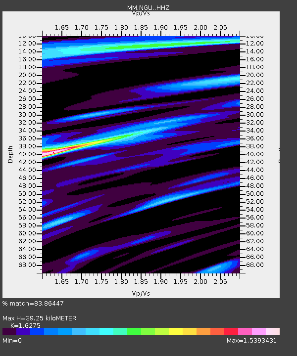
| Estimated Moho Depth: |
39.25 km |
| Estimated Crust Vp/Vs: |
1.63 |
| Assumed Crust Vp: |
6.036 km/s |
| Estimated Crust Vs: |
3.709 km/s |
| Estimated Crust Poisson's Ratio: |
0.20 |
|
| Radial Match: |
83.86447 % |
| Radial Bump: |
400 |
| Transverse Match: |
83.35814 % |
| Transverse Bump: |
400 |
| SOD ConfigId: |
19951751 |
| Insert Time: |
2019-10-30 11:43:01.178 +0000 |
| GWidth: |
2.5 |
| Max Bumps: |
400 |
| Tol: |
0.001 |
|

Signal To Noise
| Channel | StoN | STA | LTA |
| MM:NGU: :HHZ:20191016T11:43:05.169993Z | 11.592832 | 2.5664215E-6 | 2.2138003E-7 |
| MM:NGU: :HHN:20191016T11:43:05.169993Z | 1.6773144 | 3.315425E-7 | 1.9766271E-7 |
| MM:NGU: :HHE:20191016T11:43:05.169993Z | 2.2957923 | 4.6814537E-7 | 2.0391451E-7 |
| Arrivals |
| Ps | 4.4 SECOND |
| PpPs | 16 SECOND |
| PsPs/PpSs | 20 SECOND |


