You are here: Home > Network List > TA - USArray Transportable Network (new EarthScope stations) Stations List
> Station U17A Shonto, AZ, USA > Earthquake Result Viewer
U17A Shonto, AZ, USA - Earthquake Result Viewer
| Earthquake location: |
Hokkaido, Japan Region |
| Earthquake latitude/longitude: |
41.9/143.8 |
| Earthquake time(UTC): |
2008/09/11 (255) 00:20:50 GMT |
| Earthquake Depth: |
25 km |
| Earthquake Magnitude: |
6.1 MB, 7.0 MS, 6.8 MW, 6.8 MW |
| Earthquake Catalog/Contributor: |
WHDF/NEIC |
|
| Network: |
TA USArray Transportable Network (new EarthScope stations) |
| Station: |
U17A Shonto, AZ, USA |
| Lat/Lon: |
36.60 N/110.66 W |
| Elevation: |
1976 m |
|
| Distance: |
76.5 deg |
| Az: |
52.862 deg |
| Baz: |
312.3 deg |
| Ray Param: |
0.05092534 |
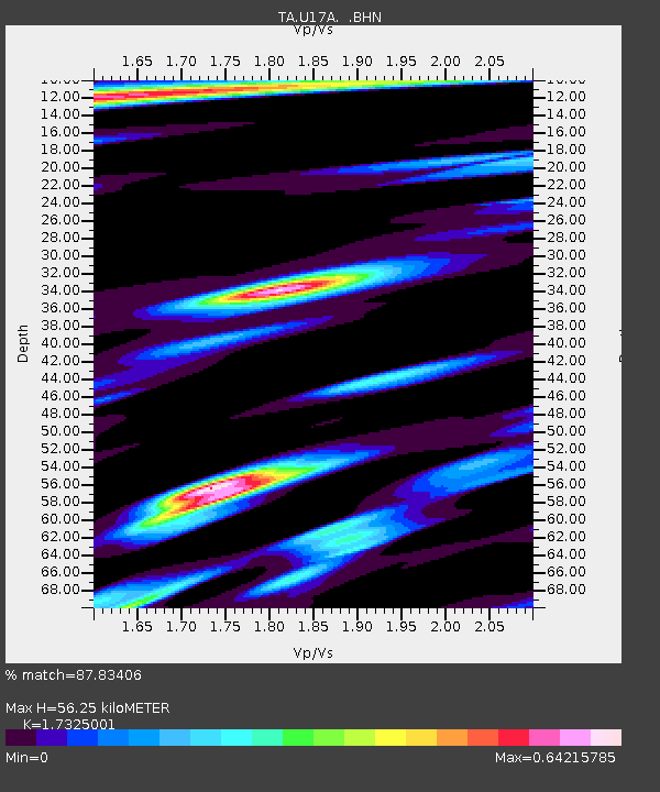
| Estimated Moho Depth: |
56.25 km |
| Estimated Crust Vp/Vs: |
1.73 |
| Assumed Crust Vp: |
6.247 km/s |
| Estimated Crust Vs: |
3.605 km/s |
| Estimated Crust Poisson's Ratio: |
0.25 |
|
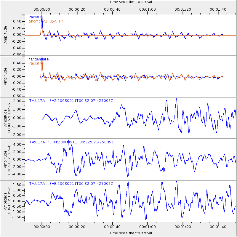
| Radial Match: |
87.83406 % |
| Radial Bump: |
400 |
| Transverse Match: |
77.47719 % |
| Transverse Bump: |
400 |
| SOD ConfigId: |
2504 |
| Insert Time: |
2010-03-07 05:03:00.731 +0000 |
| GWidth: |
2.5 |
| Max Bumps: |
400 |
| Tol: |
0.001 |
|
Signal To Noise
| Channel | StoN | STA | LTA |
| TA:U17A: :BHN:20080911T00:32:07.425005Z | 3.8676202 | 8.159161E-7 | 2.1096076E-7 |
| TA:U17A: :BHE:20080911T00:32:07.425005Z | 0.83997387 | 1.7611498E-7 | 2.0966722E-7 |
| TA:U17A: :BHZ:20080911T00:32:07.425005Z | 0.20431633 | 8.122977E-8 | 3.9756864E-7 |
| Arrivals |
| Ps | 6.8 SECOND |
| PpPs | 24 SECOND |
| PsPs/PpSs | 31 SECOND |


