You are here: Home > Network List > TA - USArray Transportable Network (new EarthScope stations) Stations List
> Station U17A Shonto, AZ, USA > Earthquake Result Viewer
U17A Shonto, AZ, USA - Earthquake Result Viewer
| Earthquake location: |
South Of Fiji Islands |
| Earthquake latitude/longitude: |
-25.8/179.5 |
| Earthquake time(UTC): |
2007/10/16 (289) 21:05:43 GMT |
| Earthquake Depth: |
509 km |
| Earthquake Magnitude: |
6.2 MB, 6.6 MW, 6.5 MW |
| Earthquake Catalog/Contributor: |
WHDF/NEIC |
|
| Network: |
TA USArray Transportable Network (new EarthScope stations) |
| Station: |
U17A Shonto, AZ, USA |
| Lat/Lon: |
36.60 N/110.66 W |
| Elevation: |
1976 m |
|
| Distance: |
90.4 deg |
| Az: |
49.051 deg |
| Baz: |
237.806 deg |
| Ray Param: |
0.04148928 |
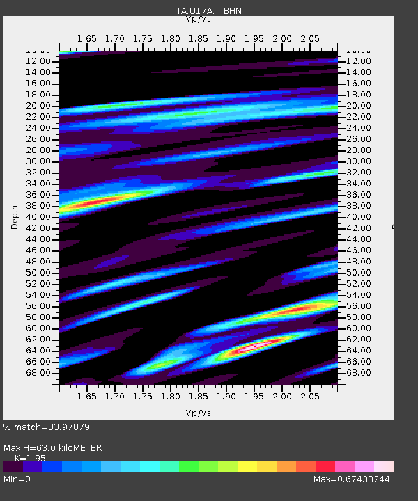
| Estimated Moho Depth: |
63.0 km |
| Estimated Crust Vp/Vs: |
1.95 |
| Assumed Crust Vp: |
6.247 km/s |
| Estimated Crust Vs: |
3.203 km/s |
| Estimated Crust Poisson's Ratio: |
0.32 |
|
| Radial Match: |
83.97879 % |
| Radial Bump: |
365 |
| Transverse Match: |
73.13552 % |
| Transverse Bump: |
400 |
| SOD ConfigId: |
2564 |
| Insert Time: |
2010-03-07 05:03:20.451 +0000 |
| GWidth: |
2.5 |
| Max Bumps: |
400 |
| Tol: |
0.001 |
|
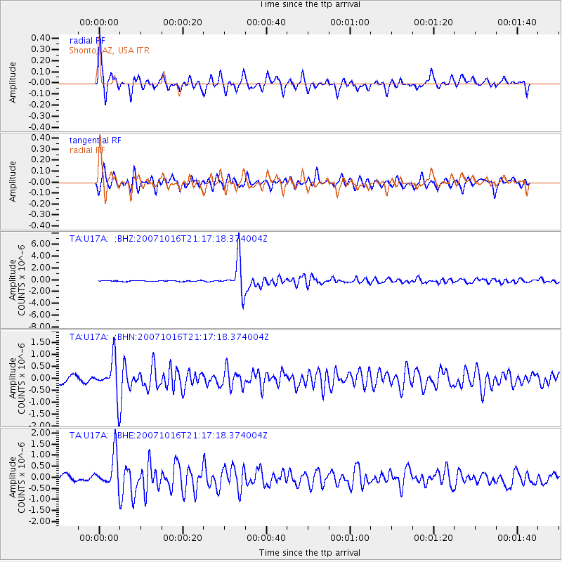
Signal To Noise
| Channel | StoN | STA | LTA |
| TA:U17A: :BHN:20071016T21:17:18.374004Z | 5.6637197 | 8.0250925E-7 | 1.4169296E-7 |
| TA:U17A: :BHE:20071016T21:17:18.374004Z | 5.872118 | 7.8823945E-7 | 1.3423427E-7 |
| TA:U17A: :BHZ:20071016T21:17:18.374004Z | 42.864754 | 2.9135126E-6 | 6.7969886E-8 |
| Arrivals |
| Ps | 9.8 SECOND |
| PpPs | 29 SECOND |
| PsPs/PpSs | 39 SECOND |


