You are here: Home > Network List > TA - USArray Transportable Network (new EarthScope stations) Stations List
> Station U17A Shonto, AZ, USA > Earthquake Result Viewer
U17A Shonto, AZ, USA - Earthquake Result Viewer
| Earthquake location: |
Galapagos Islands, Ecuador |
| Earthquake latitude/longitude: |
-0.6/-91.3 |
| Earthquake time(UTC): |
2007/08/29 (241) 22:10:10 GMT |
| Earthquake Depth: |
23 km |
| Earthquake Magnitude: |
5.6 MB, 4.8 MS, 5.4 MW |
| Earthquake Catalog/Contributor: |
WHDF/NEIC |
|
| Network: |
TA USArray Transportable Network (new EarthScope stations) |
| Station: |
U17A Shonto, AZ, USA |
| Lat/Lon: |
36.60 N/110.66 W |
| Elevation: |
1976 m |
|
| Distance: |
41.1 deg |
| Az: |
336.102 deg |
| Baz: |
149.776 deg |
| Ray Param: |
0.07397145 |
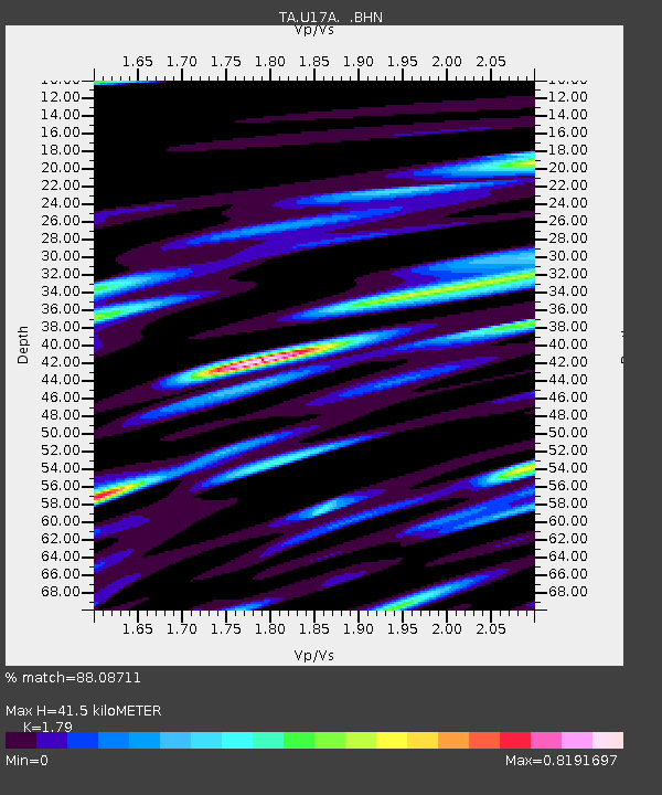
| Estimated Moho Depth: |
41.5 km |
| Estimated Crust Vp/Vs: |
1.79 |
| Assumed Crust Vp: |
6.247 km/s |
| Estimated Crust Vs: |
3.49 km/s |
| Estimated Crust Poisson's Ratio: |
0.27 |
|
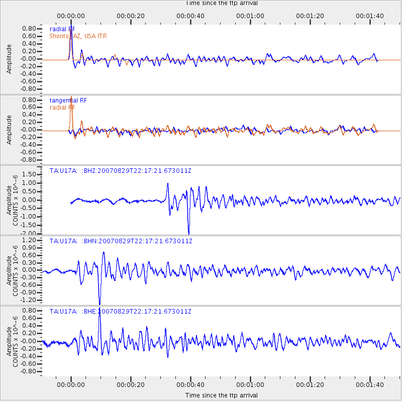
| Radial Match: |
88.08711 % |
| Radial Bump: |
400 |
| Transverse Match: |
65.71939 % |
| Transverse Bump: |
400 |
| SOD ConfigId: |
2564 |
| Insert Time: |
2010-03-07 05:03:28.809 +0000 |
| GWidth: |
2.5 |
| Max Bumps: |
400 |
| Tol: |
0.001 |
|
Signal To Noise
| Channel | StoN | STA | LTA |
| TA:U17A: :BHN:20070829T22:17:21.673011Z | 3.7699635 | 2.3759256E-7 | 6.302251E-8 |
| TA:U17A: :BHE:20070829T22:17:21.673011Z | 2.0850625 | 1.481258E-7 | 7.104143E-8 |
| TA:U17A: :BHZ:20070829T22:17:21.673011Z | 5.3053536 | 3.9733808E-7 | 7.48938E-8 |
| Arrivals |
| Ps | 5.6 SECOND |
| PpPs | 17 SECOND |
| PsPs/PpSs | 23 SECOND |


