You are here: Home > Network List > TA - USArray Transportable Network (new EarthScope stations) Stations List
> Station I30M Mount Dempster, Yukon, CAN > Earthquake Result Viewer
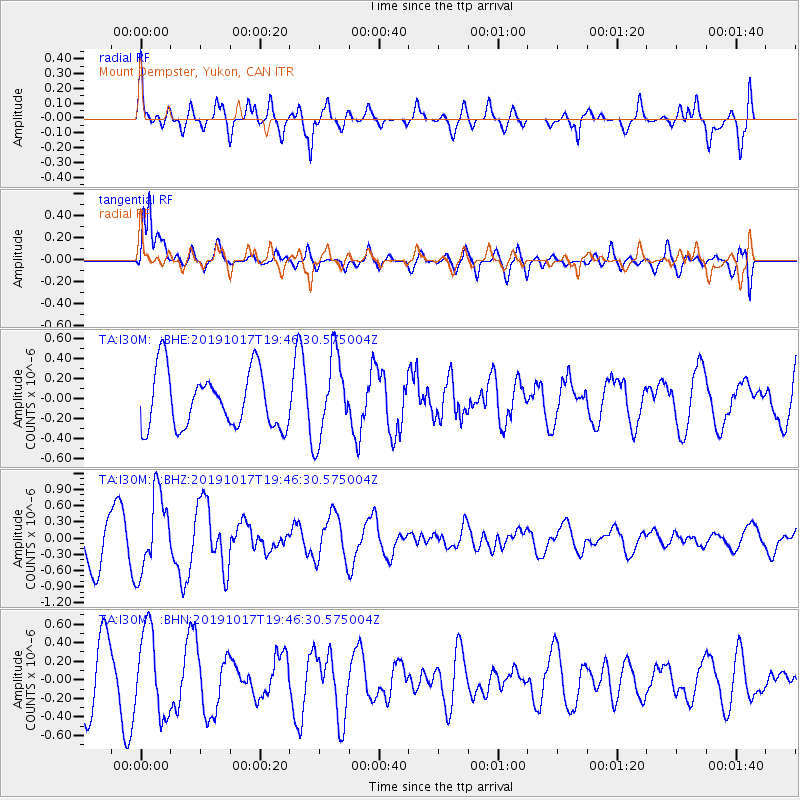
I30M Mount Dempster, Yukon, CAN - Earthquake Result Viewer
*The percent match for this event was below the threshold and hence no stack was calculated.
| Earthquake location: |
Near N Coast Of New Guinea, P.N.G. |
| Earthquake latitude/longitude: |
-2.9/141.6 |
| Earthquake time(UTC): |
2019/10/17 (290) 19:34:07 GMT |
| Earthquake Depth: |
18 km |
| Earthquake Magnitude: |
5.5 Mww |
| Earthquake Catalog/Contributor: |
NEIC PDE/us |
|
| Network: |
TA USArray Transportable Network (new EarthScope stations) |
| Station: |
I30M Mount Dempster, Yukon, CAN |
| Lat/Lon: |
65.22 N/136.38 W |
| Elevation: |
1399 m |
|
| Distance: |
89.3 deg |
| Az: |
24.667 deg |
| Baz: |
261.523 deg |
| Ray Param: |
$rayparam |
*The percent match for this event was below the threshold and hence was not used in the summary stack. |
|
| Radial Match: |
72.88578 % |
| Radial Bump: |
400 |
| Transverse Match: |
78.45886 % |
| Transverse Bump: |
400 |
| SOD ConfigId: |
19951751 |
| Insert Time: |
2019-10-31 19:47:01.276 +0000 |
| GWidth: |
2.5 |
| Max Bumps: |
400 |
| Tol: |
0.001 |
|
Signal To Noise
| Channel | StoN | STA | LTA |
| TA:I30M: :BHZ:20191017T19:46:30.575004Z | 1.9949156 | 7.2204307E-7 | 3.6194166E-7 |
| TA:I30M: :BHN:20191017T19:46:30.575004Z | 1.6181674 | 4.593037E-7 | 2.8384187E-7 |
| TA:I30M: :BHE:20191017T19:46:30.575004Z | 1.4433593 | 4.086876E-7 | 2.831503E-7 |
| Arrivals |
| Ps | |
| PpPs | |
| PsPs/PpSs | |


