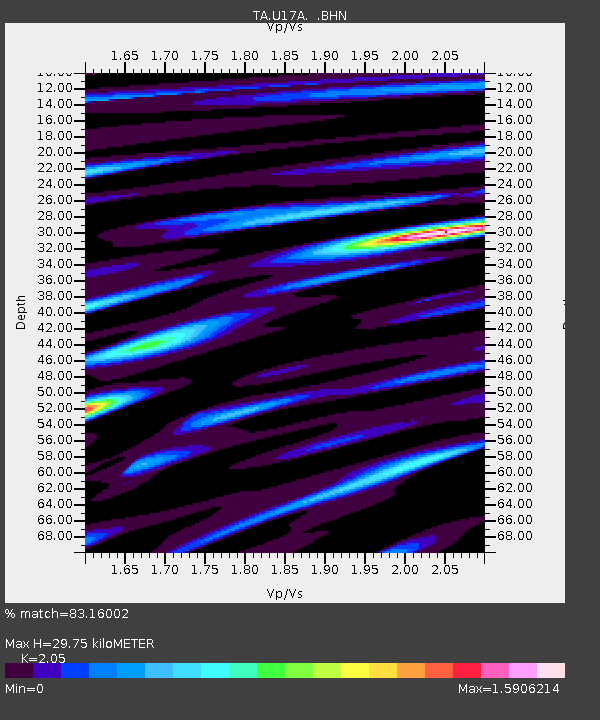
U17A Shonto, AZ, USA - Earthquake Result Viewer
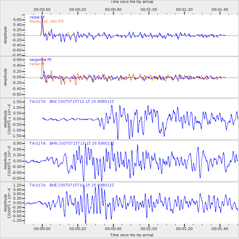
Earthquake location: Fox Islands, Aleutian Islands
Earthquake latitude/longitude: 52.5/-168.0
Earthquake time(UTC): 2007/07/15 (196) 13:08:00 GMT
Earthquake Depth: 10 km
Earthquake Magnitude: 5.8 MB, 5.9 MS, 6.1 MW, 6.0 MW
Earthquake Catalog/Contributor: WHDF/NEIC
Network: TA USArray Transportable Network (new EarthScope stations)
Station: U17A Shonto, AZ, USA
Lat/Lon: 36.60 N/110.66 W
Elevation: 1976 m
Distance: 42.7 deg
Az: 88.316 deg
Baz: 310.562 deg
Ray Param: 0.07302208
Estimated Moho Depth: 29.75 km
Estimated Crust Vp/Vs: 2.05
Assumed Crust Vp: 6.247 km/s
Estimated Crust Vs: 3.047 km/s
Estimated Crust Poisson's Ratio: 0.34
Radial Match: 83.16002 %
Radial Bump: 400
Transverse Match: 71.06996 %
Transverse Bump: 400
SOD ConfigId: 2564
Insert Time: 2010-03-07 05:03:50.657 +0000
GWidth: 2.5
Max Bumps: 400
Tol: 0.001

Signal To Noise

ChannelStoNSTALTA
TA:U17A: :BHN:20070715T13:15:26.898013Z2.32974439.570516E-84.1079684E-8
TA:U17A: :BHE:20070715T13:15:26.898013Z3.71098951.5711478E-74.2337707E-8
TA:U17A: :BHZ:20070715T13:15:26.898013Z5.89806753.2777365E-75.5573057E-8
Arrivals
Ps5.3 SECOND
PpPs14 SECOND
PsPs/PpSs19 SECOND