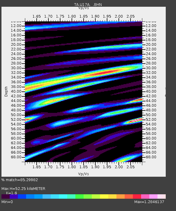
U17A Shonto, AZ, USA - Earthquake Result Viewer

Earthquake location: Andreanof Islands, Aleutian Is.
Earthquake latitude/longitude: 51.8/-176.3
Earthquake time(UTC): 2007/07/13 (194) 21:54:43 GMT
Earthquake Depth: 35 km
Earthquake Magnitude: 5.7 MB, 5.6 MS, 6.0 MW, 5.9 MW
Earthquake Catalog/Contributor: WHDF/NEIC
Network: TA USArray Transportable Network (new EarthScope stations)
Station: U17A Shonto, AZ, USA
Lat/Lon: 36.60 N/110.66 W
Elevation: 1976 m
Distance: 47.8 deg
Az: 81.634 deg
Baz: 310.288 deg
Ray Param: 0.06969065
Estimated Moho Depth: 52.25 km
Estimated Crust Vp/Vs: 1.60
Assumed Crust Vp: 6.247 km/s
Estimated Crust Vs: 3.904 km/s
Estimated Crust Poisson's Ratio: 0.18
Radial Match: 85.29982 %
Radial Bump: 400
Transverse Match: 76.258415 %
Transverse Bump: 400
SOD ConfigId: 2564
Insert Time: 2010-03-07 05:03:54.530 +0000
GWidth: 2.5
Max Bumps: 400
Tol: 0.001

Signal To Noise

ChannelStoNSTALTA
TA:U17A: :BHN:20070713T22:02:46.573013Z5.0326042.0627782E-74.0988287E-8
TA:U17A: :BHE:20070713T22:02:46.573013Z4.67523572.33945E-75.0039187E-8
TA:U17A: :BHZ:20070713T22:02:46.573013Z8.5093684.8672655E-75.719891E-8
Arrivals
Ps5.3 SECOND
PpPs20 SECOND
PsPs/PpSs26 SECOND