You are here: Home > Network List > GS - US Geological Survey Networks Stations List
> Station OK051 E0350 and S34600 Roads, Ralston, OK > Earthquake Result Viewer
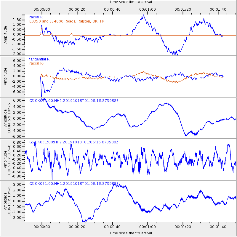
OK051 E0350 and S34600 Roads, Ralston, OK - Earthquake Result Viewer
*The percent match for this event was below the threshold and hence no stack was calculated.
| Earthquake location: |
Northern Alaska |
| Earthquake latitude/longitude: |
66.3/-157.2 |
| Earthquake time(UTC): |
2019/10/18 (291) 00:58:28 GMT |
| Earthquake Depth: |
4.4 km |
| Earthquake Magnitude: |
5.4 mww |
| Earthquake Catalog/Contributor: |
NEIC PDE/ak |
|
| Network: |
GS US Geological Survey Networks |
| Station: |
OK051 E0350 and S34600 Roads, Ralston, OK |
| Lat/Lon: |
36.51 N/96.84 W |
| Elevation: |
263 m |
|
| Distance: |
45.4 deg |
| Az: |
100.079 deg |
| Baz: |
330.394 deg |
| Ray Param: |
$rayparam |
*The percent match for this event was below the threshold and hence was not used in the summary stack. |
|
| Radial Match: |
67.56574 % |
| Radial Bump: |
400 |
| Transverse Match: |
50.67146 % |
| Transverse Bump: |
400 |
| SOD ConfigId: |
19951751 |
| Insert Time: |
2019-11-01 01:03:30.646 +0000 |
| GWidth: |
2.5 |
| Max Bumps: |
400 |
| Tol: |
0.001 |
|
Signal To Noise
| Channel | StoN | STA | LTA |
| GS:OK051:00:HHZ:20191018T01:06:16.873988Z | 1.0116457 | 3.1125765E-7 | 3.0767458E-7 |
| GS:OK051:00:HH1:20191018T01:06:16.873988Z | 0.7424598 | 1.3918718E-6 | 1.8746763E-6 |
| GS:OK051:00:HH2:20191018T01:06:16.873988Z | 2.6512063 | 5.4593734E-6 | 2.0592036E-6 |
| Arrivals |
| Ps | |
| PpPs | |
| PsPs/PpSs | |


