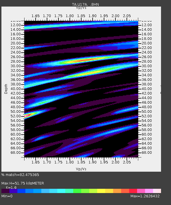
U17A Shonto, AZ, USA - Earthquake Result Viewer
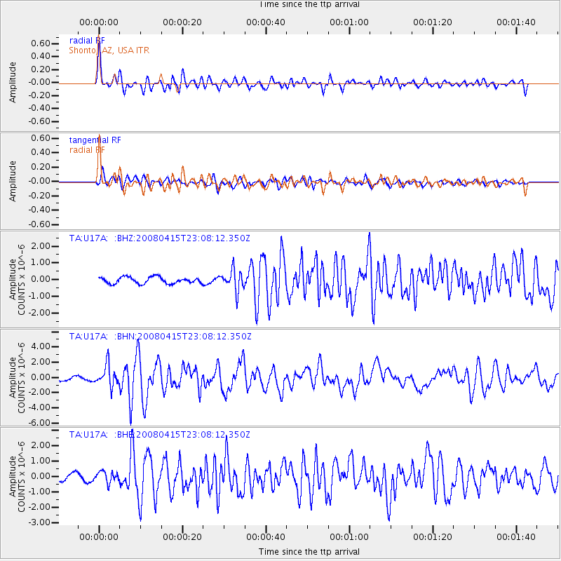
Earthquake location: Andreanof Islands, Aleutian Is.
Earthquake latitude/longitude: 51.9/-179.4
Earthquake time(UTC): 2008/04/15 (106) 22:59:51 GMT
Earthquake Depth: 10 km
Earthquake Magnitude: 6.1 MB, 6.4 MS, 6.4 MW, 6.4 MW
Earthquake Catalog/Contributor: WHDF/NEIC
Network: TA USArray Transportable Network (new EarthScope stations)
Station: U17A Shonto, AZ, USA
Lat/Lon: 36.60 N/110.66 W
Elevation: 1976 m
Distance: 49.7 deg
Az: 79.508 deg
Baz: 310.725 deg
Ray Param: 0.06854397
Estimated Moho Depth: 51.75 km
Estimated Crust Vp/Vs: 1.60
Assumed Crust Vp: 6.247 km/s
Estimated Crust Vs: 3.904 km/s
Estimated Crust Poisson's Ratio: 0.18
Radial Match: 82.475365 %
Radial Bump: 400
Transverse Match: 69.69904 %
Transverse Bump: 400
SOD ConfigId: 2504
Insert Time: 2010-03-07 05:04:11.685 +0000
GWidth: 2.5
Max Bumps: 400
Tol: 0.001

Signal To Noise

ChannelStoNSTALTA
TA:U17A: :BHN:20080415T23:08:12.350Z7.8639141.3954501E-61.7744982E-7
TA:U17A: :BHE:20080415T23:08:12.350Z1.63400353.6153372E-72.2125639E-7
TA:U17A: :BHZ:20080415T23:08:12.350Z3.31586346.241535E-71.8823258E-7
Arrivals
Ps5.3 SECOND
PpPs20 SECOND
PsPs/PpSs26 SECOND