You are here: Home > Network List > TA - USArray Transportable Network (new EarthScope stations) Stations List
> Station U17A Shonto, AZ, USA > Earthquake Result Viewer
U17A Shonto, AZ, USA - Earthquake Result Viewer
| Earthquake location: |
Vanuatu Islands |
| Earthquake latitude/longitude: |
-19.9/169.0 |
| Earthquake time(UTC): |
2008/04/28 (119) 18:33:34 GMT |
| Earthquake Depth: |
32 km |
| Earthquake Magnitude: |
6.2 MB, 6.2 MS, 6.4 MW, 6.4 MW |
| Earthquake Catalog/Contributor: |
WHDF/NEIC |
|
| Network: |
TA USArray Transportable Network (new EarthScope stations) |
| Station: |
U17A Shonto, AZ, USA |
| Lat/Lon: |
36.60 N/110.66 W |
| Elevation: |
1976 m |
|
| Distance: |
94.3 deg |
| Az: |
52.717 deg |
| Baz: |
248.46 deg |
| Ray Param: |
0.041065887 |
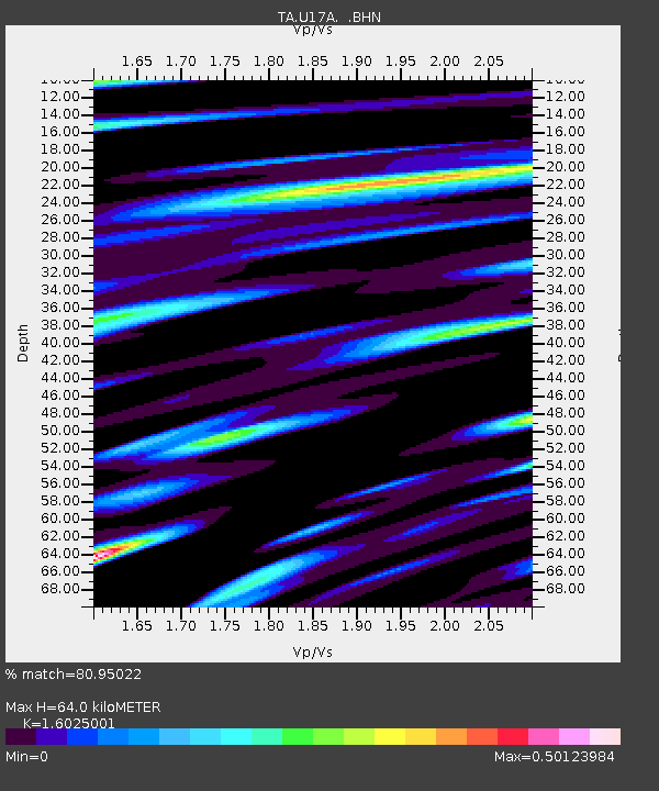
| Estimated Moho Depth: |
64.0 km |
| Estimated Crust Vp/Vs: |
1.60 |
| Assumed Crust Vp: |
6.247 km/s |
| Estimated Crust Vs: |
3.898 km/s |
| Estimated Crust Poisson's Ratio: |
0.18 |
|
| Radial Match: |
80.95022 % |
| Radial Bump: |
384 |
| Transverse Match: |
74.4584 % |
| Transverse Bump: |
400 |
| SOD ConfigId: |
2504 |
| Insert Time: |
2010-03-07 05:04:16.092 +0000 |
| GWidth: |
2.5 |
| Max Bumps: |
400 |
| Tol: |
0.001 |
|
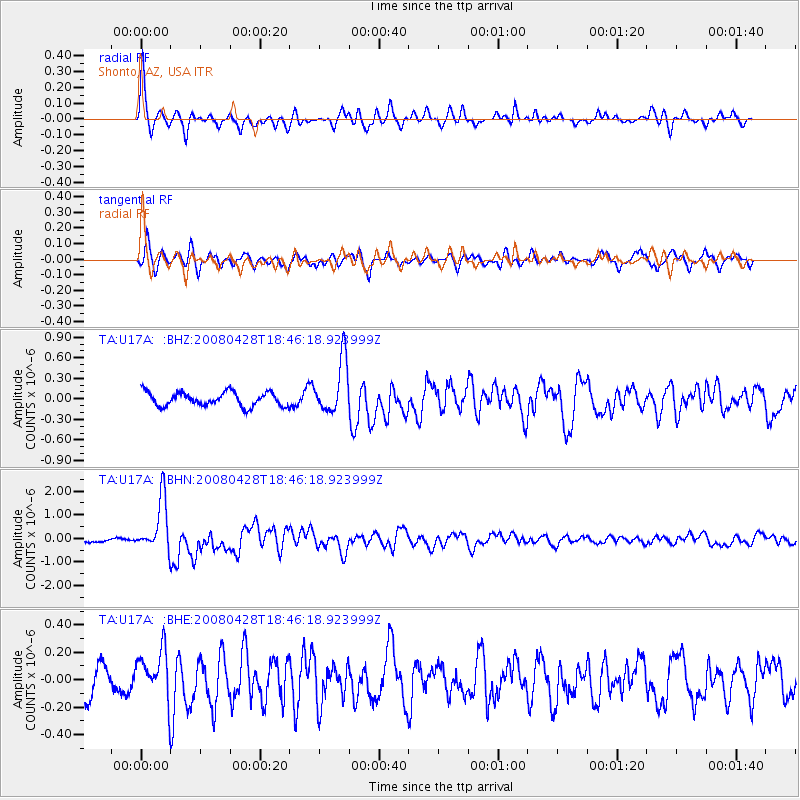
Signal To Noise
| Channel | StoN | STA | LTA |
| TA:U17A: :BHN:20080428T18:46:18.923999Z | 11.687258 | 1.1186737E-6 | 9.571738E-8 |
| TA:U17A: :BHE:20080428T18:46:18.923999Z | 1.4714592 | 1.8598601E-7 | 1.2639563E-7 |
| TA:U17A: :BHZ:20080428T18:46:18.923999Z | 3.833169 | 3.894005E-7 | 1.015871E-7 |
| Arrivals |
| Ps | 6.3 SECOND |
| PpPs | 26 SECOND |
| PsPs/PpSs | 32 SECOND |


