You are here: Home > Network List > US - United States National Seismic Network Stations List
> Station DGMT Dagmar, Montana, USA > Earthquake Result Viewer
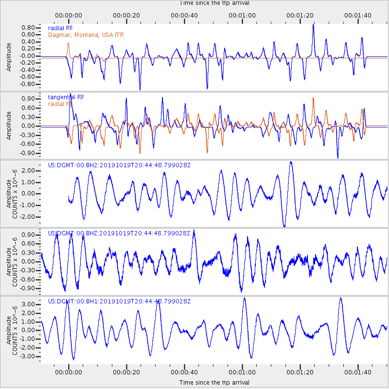
DGMT Dagmar, Montana, USA - Earthquake Result Viewer
*The percent match for this event was below the threshold and hence no stack was calculated.
| Earthquake location: |
Fiji Islands |
| Earthquake latitude/longitude: |
-18.9/178.1 |
| Earthquake time(UTC): |
2019/10/19 (292) 20:31:56 GMT |
| Earthquake Depth: |
37 km |
| Earthquake Magnitude: |
5.7 Mww |
| Earthquake Catalog/Contributor: |
NEIC PDE/us |
|
| Network: |
US United States National Seismic Network |
| Station: |
DGMT Dagmar, Montana, USA |
| Lat/Lon: |
48.47 N/104.20 W |
| Elevation: |
0.0 m |
|
| Distance: |
96.1 deg |
| Az: |
40.841 deg |
| Baz: |
248.504 deg |
| Ray Param: |
$rayparam |
*The percent match for this event was below the threshold and hence was not used in the summary stack. |
|
| Radial Match: |
60.925564 % |
| Radial Bump: |
327 |
| Transverse Match: |
66.93119 % |
| Transverse Bump: |
363 |
| SOD ConfigId: |
19951751 |
| Insert Time: |
2019-11-02 20:41:53.314 +0000 |
| GWidth: |
2.5 |
| Max Bumps: |
400 |
| Tol: |
0.001 |
|
Signal To Noise
| Channel | StoN | STA | LTA |
| US:DGMT:00:BHZ:20191019T20:44:48.799028Z | 1.5799067 | 6.1352205E-7 | 3.8832803E-7 |
| US:DGMT:00:BH1:20191019T20:44:48.799028Z | 3.6160908 | 2.2457923E-6 | 6.2105534E-7 |
| US:DGMT:00:BH2:20191019T20:44:48.799028Z | 0.9816269 | 9.830666E-7 | 1.0014666E-6 |
| Arrivals |
| Ps | |
| PpPs | |
| PsPs/PpSs | |


