You are here: Home > Network List > TA - USArray Transportable Network (new EarthScope stations) Stations List
> Station U17A Shonto, AZ, USA > Earthquake Result Viewer
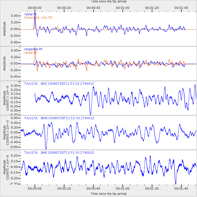
U17A Shonto, AZ, USA - Earthquake Result Viewer
*The percent match for this event was below the threshold and hence no stack was calculated.
| Earthquake location: |
Solomon Islands |
| Earthquake latitude/longitude: |
-10.6/163.1 |
| Earthquake time(UTC): |
2008/07/28 (210) 21:40:47 GMT |
| Earthquake Depth: |
10 km |
| Earthquake Magnitude: |
5.9 MB, 5.8 MS, 6.0 MW |
| Earthquake Catalog/Contributor: |
WHDF/NEIC |
|
| Network: |
TA USArray Transportable Network (new EarthScope stations) |
| Station: |
U17A Shonto, AZ, USA |
| Lat/Lon: |
36.60 N/110.66 W |
| Elevation: |
1976 m |
|
| Distance: |
93.2 deg |
| Az: |
53.54 deg |
| Baz: |
259.316 deg |
| Ray Param: |
$rayparam |
*The percent match for this event was below the threshold and hence was not used in the summary stack. |
|
| Radial Match: |
79.08702 % |
| Radial Bump: |
400 |
| Transverse Match: |
52.55347 % |
| Transverse Bump: |
400 |
| SOD ConfigId: |
2504 |
| Insert Time: |
2010-03-07 05:04:54.445 +0000 |
| GWidth: |
2.5 |
| Max Bumps: |
400 |
| Tol: |
0.001 |
|
Signal To Noise
| Channel | StoN | STA | LTA |
| TA:U17A: :BHN:20080728T21:53:30.274001Z | 0.7308716 | 7.689554E-8 | 1.0521073E-7 |
| TA:U17A: :BHE:20080728T21:53:30.274001Z | 1.0698669 | 5.6872555E-8 | 5.3158537E-8 |
| TA:U17A: :BHZ:20080728T21:53:30.274001Z | 1.3673385 | 8.241643E-8 | 6.027507E-8 |
| Arrivals |
| Ps | |
| PpPs | |
| PsPs/PpSs | |


