You are here: Home > Network List > TA - USArray Transportable Network (new EarthScope stations) Stations List
> Station U17A Shonto, AZ, USA > Earthquake Result Viewer
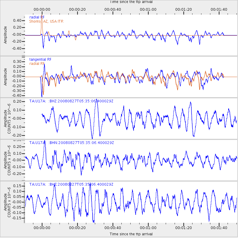
U17A Shonto, AZ, USA - Earthquake Result Viewer
*The percent match for this event was below the threshold and hence no stack was calculated.
| Earthquake location: |
Kuril Islands |
| Earthquake latitude/longitude: |
46.7/152.5 |
| Earthquake time(UTC): |
2008/08/27 (240) 05:24:41 GMT |
| Earthquake Depth: |
65 km |
| Earthquake Magnitude: |
5.5 MB, 5.4 MW, 5.3 MW |
| Earthquake Catalog/Contributor: |
WHDF/NEIC |
|
| Network: |
TA USArray Transportable Network (new EarthScope stations) |
| Station: |
U17A Shonto, AZ, USA |
| Lat/Lon: |
36.60 N/110.66 W |
| Elevation: |
1976 m |
|
| Distance: |
68.6 deg |
| Az: |
59.105 deg |
| Baz: |
312.813 deg |
| Ray Param: |
$rayparam |
*The percent match for this event was below the threshold and hence was not used in the summary stack. |
|
| Radial Match: |
39.017445 % |
| Radial Bump: |
400 |
| Transverse Match: |
45.02126 % |
| Transverse Bump: |
400 |
| SOD ConfigId: |
2504 |
| Insert Time: |
2010-03-07 05:05:18.501 +0000 |
| GWidth: |
2.5 |
| Max Bumps: |
400 |
| Tol: |
0.001 |
|
Signal To Noise
| Channel | StoN | STA | LTA |
| TA:U17A: :BHN:20080827T05:35:06.400029Z | 2.7177207 | 1.2987455E-7 | 4.7788042E-8 |
| TA:U17A: :BHE:20080827T05:35:06.400029Z | 0.74307424 | 5.2981974E-8 | 7.130105E-8 |
| TA:U17A: :BHZ:20080827T05:35:06.400029Z | 2.2896504 | 1.3906673E-7 | 6.0737094E-8 |
| Arrivals |
| Ps | |
| PpPs | |
| PsPs/PpSs | |


