You are here: Home > Network List > AV - Alaska Volcano Observatory Stations List
> Station KOKL Mount Kliuchef, Korovin Volcano, Alaska > Earthquake Result Viewer
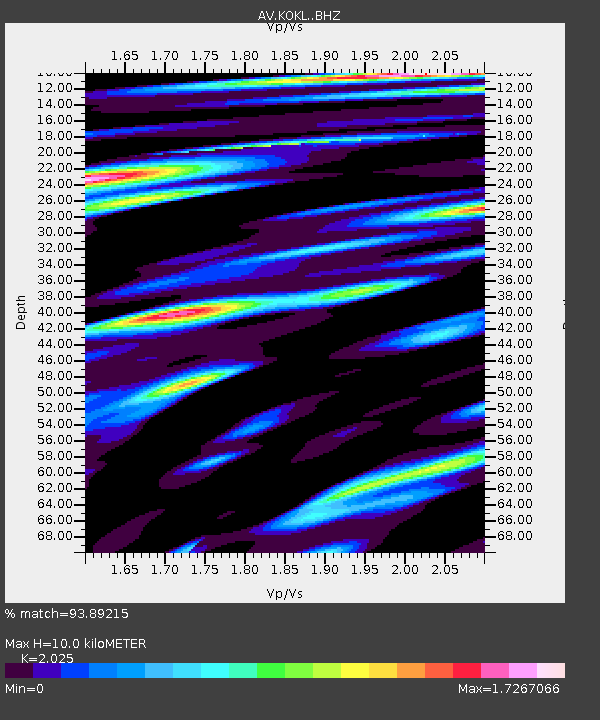
KOKL Mount Kliuchef, Korovin Volcano, Alaska - Earthquake Result Viewer
| Earthquake location: |
Vanuatu Islands |
| Earthquake latitude/longitude: |
-19.0/169.5 |
| Earthquake time(UTC): |
2019/10/21 (294) 02:52:29 GMT |
| Earthquake Depth: |
226 km |
| Earthquake Magnitude: |
6.4 Mww |
| Earthquake Catalog/Contributor: |
NEIC PDE/us |
|
| Network: |
AV Alaska Volcano Observatory |
| Station: |
KOKL Mount Kliuchef, Korovin Volcano, Alaska |
| Lat/Lon: |
52.32 N/174.20 W |
| Elevation: |
758 m |
|
| Distance: |
72.5 deg |
| Az: |
10.436 deg |
| Baz: |
196.211 deg |
| Ray Param: |
0.053020336 |
| Estimated Moho Depth: |
10.0 km |
| Estimated Crust Vp/Vs: |
2.03 |
| Assumed Crust Vp: |
5.88 km/s |
| Estimated Crust Vs: |
2.904 km/s |
| Estimated Crust Poisson's Ratio: |
0.34 |
|
| Radial Match: |
93.89215 % |
| Radial Bump: |
400 |
| Transverse Match: |
92.00628 % |
| Transverse Bump: |
400 |
| SOD ConfigId: |
19951751 |
| Insert Time: |
2019-11-04 02:58:19.566 +0000 |
| GWidth: |
2.5 |
| Max Bumps: |
400 |
| Tol: |
0.001 |
|

Signal To Noise
| Channel | StoN | STA | LTA |
| AV:KOKL: :BHZ:20191021T03:02:59.998973Z | 29.63553 | 9.004083E-6 | 3.0382728E-7 |
| AV:KOKL: :BHN:20191021T03:02:59.998973Z | 17.503052 | 9.8622895E-6 | 5.6346113E-7 |
| AV:KOKL: :BHE:20191021T03:02:59.998973Z | 14.206582 | 6.423284E-6 | 4.5213437E-7 |
| Arrivals |
| Ps | 1.8 SECOND |
| PpPs | 5.0 SECOND |
| PsPs/PpSs | 6.8 SECOND |


