You are here: Home > Network List > TA - USArray Transportable Network (new EarthScope stations) Stations List
> Station O24A Longmont, CO, USA > Earthquake Result Viewer
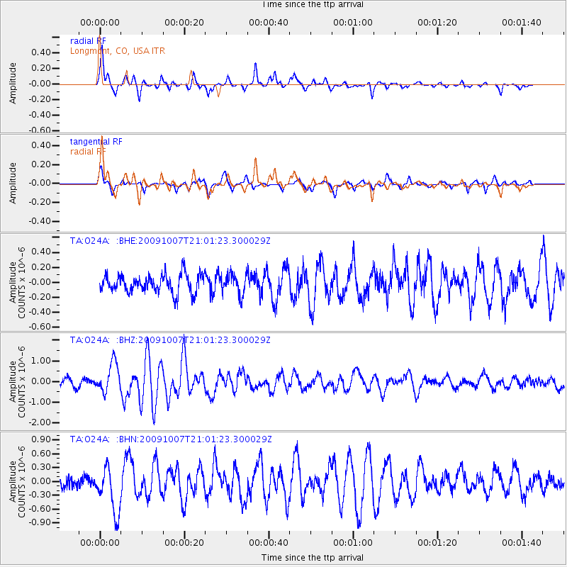
O24A Longmont, CO, USA - Earthquake Result Viewer

| Earthquake location: |
East Of Severnaya Zemlya |
| Earthquake latitude/longitude: |
81.6/119.5 |
| Earthquake time(UTC): |
2009/10/07 (280) 20:52:13 GMT |
| Earthquake Depth: |
8.0 km |
| Earthquake Magnitude: |
5.7 MB, 5.1 MS, 5.8 MW, 5.8 MW |
| Earthquake Catalog/Contributor: |
WHDF/NEIC |
|
| Network: |
TA USArray Transportable Network (new EarthScope stations) |
| Station: |
O24A Longmont, CO, USA |
| Lat/Lon: |
40.12 N/105.07 W |
| Elevation: |
1553 m |
|
| Distance: |
56.3 deg |
| Az: |
40.313 deg |
| Baz: |
352.849 deg |
| Ray Param: |
0.06421342 |
| Estimated Moho Depth: |
19.25 km |
| Estimated Crust Vp/Vs: |
1.60 |
| Assumed Crust Vp: |
6.306 km/s |
| Estimated Crust Vs: |
3.941 km/s |
| Estimated Crust Poisson's Ratio: |
0.18 |
|
| Radial Match: |
80.89959 % |
| Radial Bump: |
400 |
| Transverse Match: |
72.24129 % |
| Transverse Bump: |
400 |
| SOD ConfigId: |
2622 |
| Insert Time: |
2010-03-07 05:05:52.645 +0000 |
| GWidth: |
2.5 |
| Max Bumps: |
400 |
| Tol: |
0.001 |
|
Signal To Noise
| Channel | StoN | STA | LTA |
| TA:O24A: :BHZ:20091007T21:01:23.300029Z | 3.9791837 | 7.2690955E-7 | 1.8267806E-7 |
| TA:O24A: :BHN:20091007T21:01:23.300029Z | 3.9696567 | 5.1452093E-7 | 1.2961345E-7 |
| TA:O24A: :BHE:20091007T21:01:23.300029Z | 1.1913933 | 1.4060198E-7 | 1.1801475E-7 |
| Arrivals |
| Ps | 1.9 SECOND |
| PpPs | 7.5 SECOND |
| PsPs/PpSs | 9.5 SECOND |


