You are here: Home > Network List > TA - USArray Transportable Network (new EarthScope stations) Stations List
> Station O24A Longmont, CO, USA > Earthquake Result Viewer
O24A Longmont, CO, USA - Earthquake Result Viewer
| Earthquake location: |
Azores Islands Region |
| Earthquake latitude/longitude: |
36.2/-33.9 |
| Earthquake time(UTC): |
2009/11/04 (308) 18:41:44 GMT |
| Earthquake Depth: |
10 km |
| Earthquake Magnitude: |
5.7 MB, 5.6 MS, 5.9 MW, 5.8 MW |
| Earthquake Catalog/Contributor: |
WHDF/NEIC |
|
| Network: |
TA USArray Transportable Network (new EarthScope stations) |
| Station: |
O24A Longmont, CO, USA |
| Lat/Lon: |
40.12 N/105.07 W |
| Elevation: |
1553 m |
|
| Distance: |
54.8 deg |
| Az: |
297.28 deg |
| Baz: |
69.728 deg |
| Ray Param: |
0.06524594 |
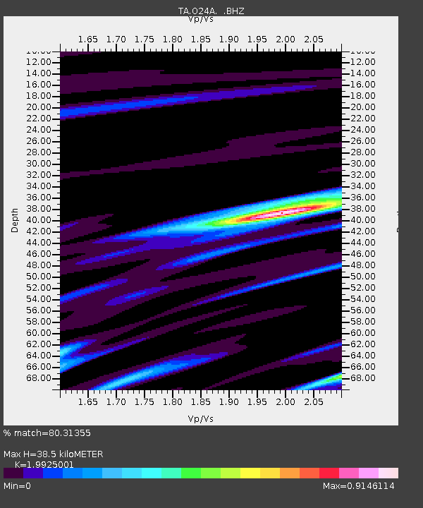
| Estimated Moho Depth: |
38.5 km |
| Estimated Crust Vp/Vs: |
1.99 |
| Assumed Crust Vp: |
6.306 km/s |
| Estimated Crust Vs: |
3.165 km/s |
| Estimated Crust Poisson's Ratio: |
0.33 |
|
| Radial Match: |
80.31355 % |
| Radial Bump: |
296 |
| Transverse Match: |
62.801617 % |
| Transverse Bump: |
400 |
| SOD ConfigId: |
2622 |
| Insert Time: |
2010-03-07 05:05:57.187 +0000 |
| GWidth: |
2.5 |
| Max Bumps: |
400 |
| Tol: |
0.001 |
|

Signal To Noise
| Channel | StoN | STA | LTA |
| TA:O24A: :BHZ:20091104T18:50:43.000015Z | 5.907958 | 1.2269757E-6 | 2.0768185E-7 |
| TA:O24A: :BHN:20091104T18:50:43.000015Z | 1.9852638 | 2.7125608E-7 | 1.3663478E-7 |
| TA:O24A: :BHE:20091104T18:50:43.000015Z | 3.8618705 | 5.8708974E-7 | 1.5202212E-7 |
| Arrivals |
| Ps | 6.3 SECOND |
| PpPs | 17 SECOND |
| PsPs/PpSs | 24 SECOND |


