You are here: Home > Network List > TA - USArray Transportable Network (new EarthScope stations) Stations List
> Station O24A Longmont, CO, USA > Earthquake Result Viewer
O24A Longmont, CO, USA - Earthquake Result Viewer
| Earthquake location: |
South Of Panama |
| Earthquake latitude/longitude: |
5.7/-82.8 |
| Earthquake time(UTC): |
2009/03/12 (071) 23:23:34 GMT |
| Earthquake Depth: |
9.0 km |
| Earthquake Magnitude: |
6.1 MB, 5.9 MS, 6.3 MW, 6.2 MW |
| Earthquake Catalog/Contributor: |
WHDF/NEIC |
|
| Network: |
TA USArray Transportable Network (new EarthScope stations) |
| Station: |
O24A Longmont, CO, USA |
| Lat/Lon: |
40.12 N/105.07 W |
| Elevation: |
1553 m |
|
| Distance: |
39.7 deg |
| Az: |
332.909 deg |
| Baz: |
143.77 deg |
| Ray Param: |
0.07482267 |
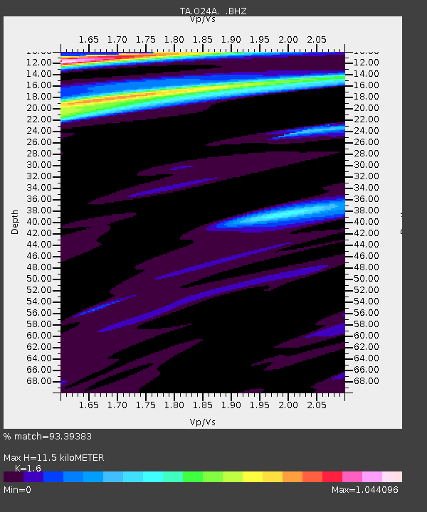
| Estimated Moho Depth: |
11.5 km |
| Estimated Crust Vp/Vs: |
1.60 |
| Assumed Crust Vp: |
6.306 km/s |
| Estimated Crust Vs: |
3.941 km/s |
| Estimated Crust Poisson's Ratio: |
0.18 |
|
| Radial Match: |
93.39383 % |
| Radial Bump: |
320 |
| Transverse Match: |
64.558365 % |
| Transverse Bump: |
400 |
| SOD ConfigId: |
2658 |
| Insert Time: |
2010-03-07 05:06:10.587 +0000 |
| GWidth: |
2.5 |
| Max Bumps: |
400 |
| Tol: |
0.001 |
|

Signal To Noise
| Channel | StoN | STA | LTA |
| TA:O24A: :BHZ:20090312T23:30:36.64901Z | 3.8532648 | 8.8726534E-7 | 2.3026327E-7 |
| TA:O24A: :BHN:20090312T23:30:36.64901Z | 1.8109831 | 2.3100192E-7 | 1.2755609E-7 |
| TA:O24A: :BHE:20090312T23:30:36.64901Z | 1.7204268 | 3.0661153E-7 | 1.7821829E-7 |
| Arrivals |
| Ps | 1.2 SECOND |
| PpPs | 4.4 SECOND |
| PsPs/PpSs | 5.6 SECOND |


