You are here: Home > Network List > G - GEOSCOPE Stations List
> Station WUS Wushi, Xinjiang Uygur, China > Earthquake Result Viewer
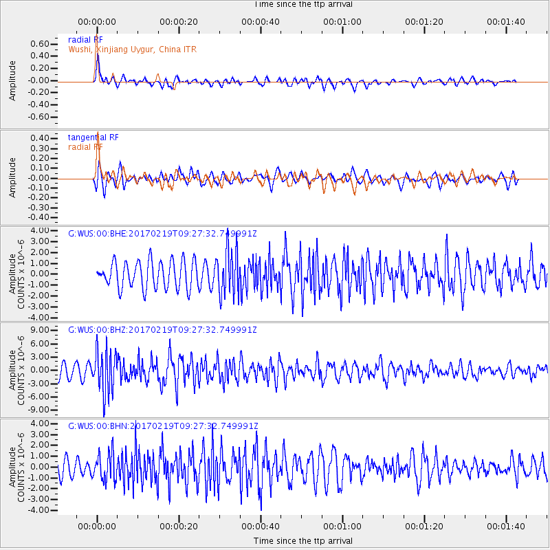
WUS Wushi, Xinjiang Uygur, China - Earthquake Result Viewer
*The percent match for this event was below the threshold and hence no stack was calculated.
| Earthquake location: |
Near East Coast Of Honshu, Japan |
| Earthquake latitude/longitude: |
35.6/140.8 |
| Earthquake time(UTC): |
2017/02/19 (050) 09:19:30 GMT |
| Earthquake Depth: |
39 km |
| Earthquake Magnitude: |
5.5 mb |
| Earthquake Catalog/Contributor: |
NEIC PDE/us |
|
| Network: |
G GEOSCOPE |
| Station: |
WUS Wushi, Xinjiang Uygur, China |
| Lat/Lon: |
41.20 N/79.22 E |
| Elevation: |
1457 m |
|
| Distance: |
47.7 deg |
| Az: |
296.178 deg |
| Baz: |
75.647 deg |
| Ray Param: |
$rayparam |
*The percent match for this event was below the threshold and hence was not used in the summary stack. |
|
| Radial Match: |
64.95003 % |
| Radial Bump: |
400 |
| Transverse Match: |
67.268555 % |
| Transverse Bump: |
400 |
| SOD ConfigId: |
1992691 |
| Insert Time: |
2017-03-05 09:20:28.841 +0000 |
| GWidth: |
2.5 |
| Max Bumps: |
400 |
| Tol: |
0.001 |
|
Signal To Noise
| Channel | StoN | STA | LTA |
| G:WUS:00:BHZ:20170219T09:27:32.749991Z | 2.869942 | 4.8954807E-6 | 1.705777E-6 |
| G:WUS:00:BHN:20170219T09:27:32.749991Z | 1.4166403 | 1.2820506E-6 | 9.0499367E-7 |
| G:WUS:00:BHE:20170219T09:27:32.749991Z | 1.7078878 | 2.0937562E-6 | 1.2259331E-6 |
| Arrivals |
| Ps | |
| PpPs | |
| PsPs/PpSs | |


