You are here: Home > Network List > MM - Myanmar National Seismic Network Stations List
> Station KTN Keng Tun, Shan, Myanmar > Earthquake Result Viewer
KTN Keng Tun, Shan, Myanmar - Earthquake Result Viewer
| Earthquake location: |
Vanuatu Islands |
| Earthquake latitude/longitude: |
-19.0/169.5 |
| Earthquake time(UTC): |
2019/10/21 (294) 02:52:29 GMT |
| Earthquake Depth: |
226 km |
| Earthquake Magnitude: |
6.4 Mww |
| Earthquake Catalog/Contributor: |
NEIC PDE/us |
|
| Network: |
MM Myanmar National Seismic Network |
| Station: |
KTN Keng Tun, Shan, Myanmar |
| Lat/Lon: |
21.29 N/99.59 E |
| Elevation: |
832 m |
|
| Distance: |
79.2 deg |
| Az: |
296.968 deg |
| Baz: |
115.308 deg |
| Ray Param: |
0.048517585 |
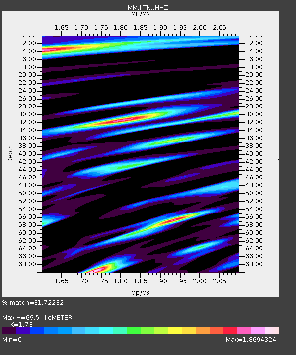
| Estimated Moho Depth: |
69.5 km |
| Estimated Crust Vp/Vs: |
1.73 |
| Assumed Crust Vp: |
6.316 km/s |
| Estimated Crust Vs: |
3.651 km/s |
| Estimated Crust Poisson's Ratio: |
0.25 |
|
| Radial Match: |
81.72232 % |
| Radial Bump: |
400 |
| Transverse Match: |
69.71844 % |
| Transverse Bump: |
400 |
| SOD ConfigId: |
19951751 |
| Insert Time: |
2019-11-04 03:02:17.039 +0000 |
| GWidth: |
2.5 |
| Max Bumps: |
400 |
| Tol: |
0.001 |
|

Signal To Noise
| Channel | StoN | STA | LTA |
| MM:KTN: :HHZ:20191021T03:03:38.088023Z | 10.979916 | 4.555855E-6 | 4.1492623E-7 |
| MM:KTN: :HHN:20191021T03:03:38.088023Z | 1.9676162 | 1.1466003E-6 | 5.827357E-7 |
| MM:KTN: :HHE:20191021T03:03:38.088023Z | 3.4546032 | 1.934158E-6 | 5.598785E-7 |
| Arrivals |
| Ps | 8.3 SECOND |
| PpPs | 29 SECOND |
| PsPs/PpSs | 37 SECOND |


