You are here: Home > Network List > PF - Volcanologic Network of Piton de Fournaise-OVPF Stations List
> Station FRE Station Sismologique des Fonds de la Riviere de l'Est > Earthquake Result Viewer
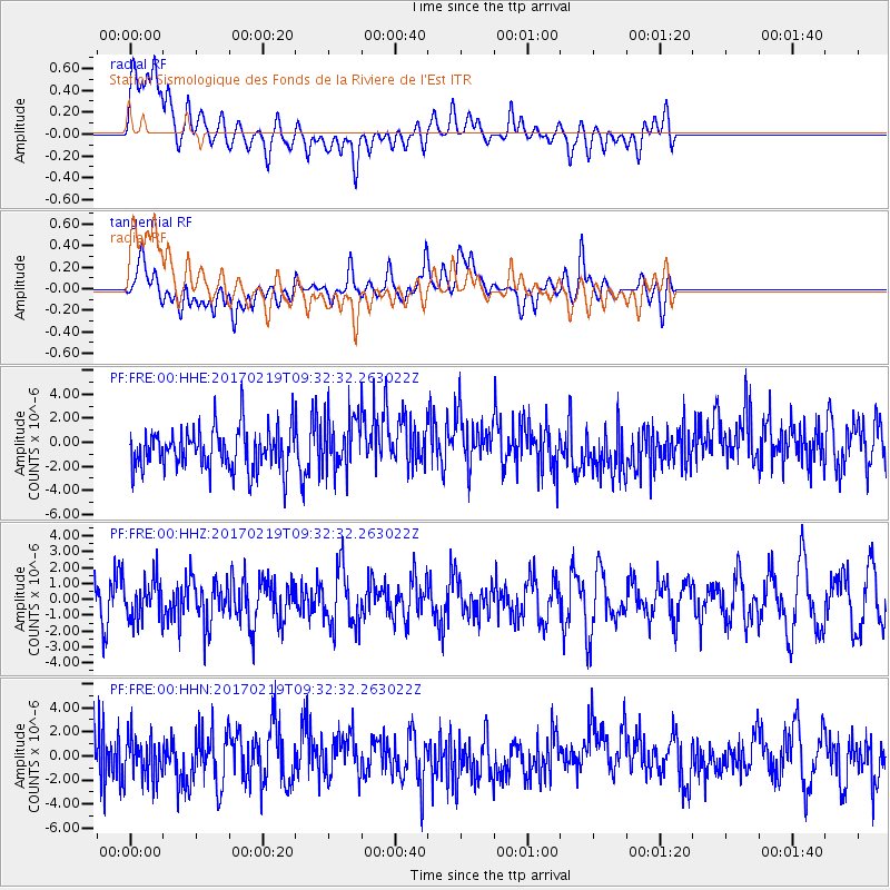
FRE Station Sismologique des Fonds de la Riviere de l'Est - Earthquake Result Viewer
*The percent match for this event was below the threshold and hence no stack was calculated.
| Earthquake location: |
Near East Coast Of Honshu, Japan |
| Earthquake latitude/longitude: |
35.6/140.8 |
| Earthquake time(UTC): |
2017/02/19 (050) 09:19:30 GMT |
| Earthquake Depth: |
39 km |
| Earthquake Magnitude: |
5.5 mb |
| Earthquake Catalog/Contributor: |
NEIC PDE/us |
|
| Network: |
PF Volcanologic Network of Piton de Fournaise-OVPF |
| Station: |
FRE Station Sismologique des Fonds de la Riviere de l'Est |
| Lat/Lon: |
21.20 S/55.70 E |
| Elevation: |
1775 m |
|
| Distance: |
98.3 deg |
| Az: |
249.966 deg |
| Baz: |
55.102 deg |
| Ray Param: |
$rayparam |
*The percent match for this event was below the threshold and hence was not used in the summary stack. |
|
| Radial Match: |
47.57345 % |
| Radial Bump: |
400 |
| Transverse Match: |
52.032185 % |
| Transverse Bump: |
400 |
| SOD ConfigId: |
1992691 |
| Insert Time: |
2017-03-05 09:24:10.819 +0000 |
| GWidth: |
2.5 |
| Max Bumps: |
400 |
| Tol: |
0.001 |
|
Signal To Noise
| Channel | StoN | STA | LTA |
| PF:FRE:00:HHZ:20170219T09:32:32.263022Z | 1.2667972 | 1.255882E-6 | 9.913837E-7 |
| PF:FRE:00:HHN:20170219T09:32:32.263022Z | 1.1167356 | 1.8052195E-6 | 1.6165147E-6 |
| PF:FRE:00:HHE:20170219T09:32:32.263022Z | 1.2989132 | 2.2501483E-6 | 1.7323315E-6 |
| Arrivals |
| Ps | |
| PpPs | |
| PsPs/PpSs | |


