You are here: Home > Network List > TA - USArray Transportable Network (new EarthScope stations) Stations List
> Station B18K Kokolik River, AK, USA > Earthquake Result Viewer
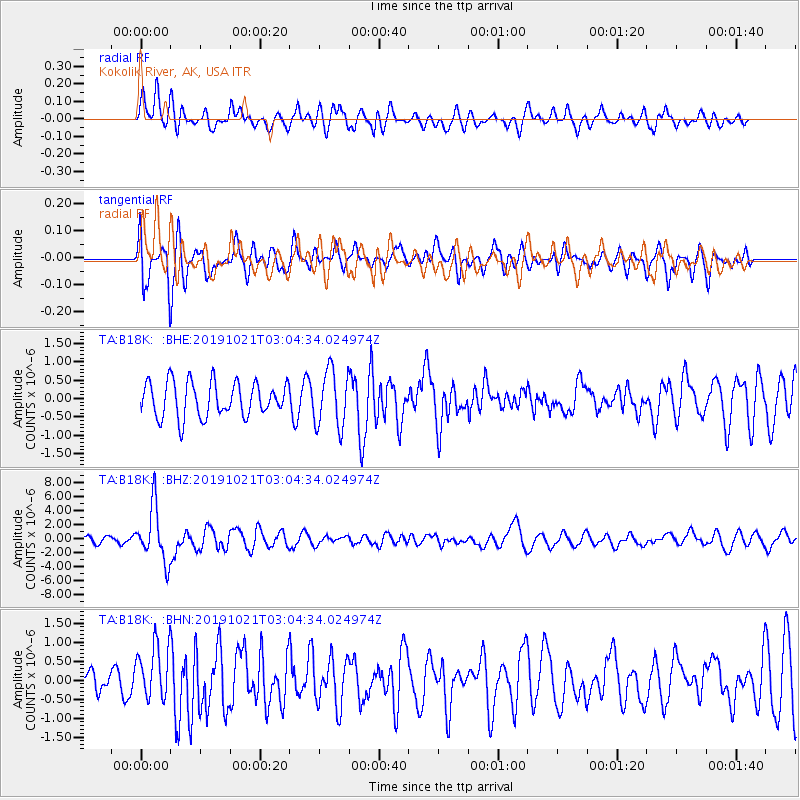
B18K Kokolik River, AK, USA - Earthquake Result Viewer
*The percent match for this event was below the threshold and hence no stack was calculated.
| Earthquake location: |
Vanuatu Islands |
| Earthquake latitude/longitude: |
-19.0/169.5 |
| Earthquake time(UTC): |
2019/10/21 (294) 02:52:29 GMT |
| Earthquake Depth: |
226 km |
| Earthquake Magnitude: |
6.4 Mww |
| Earthquake Catalog/Contributor: |
NEIC PDE/us |
|
| Network: |
TA USArray Transportable Network (new EarthScope stations) |
| Station: |
B18K Kokolik River, AK, USA |
| Lat/Lon: |
69.36 N/161.80 W |
| Elevation: |
222 m |
|
| Distance: |
90.5 deg |
| Az: |
9.817 deg |
| Baz: |
207.062 deg |
| Ray Param: |
$rayparam |
*The percent match for this event was below the threshold and hence was not used in the summary stack. |
|
| Radial Match: |
70.52762 % |
| Radial Bump: |
400 |
| Transverse Match: |
73.07675 % |
| Transverse Bump: |
400 |
| SOD ConfigId: |
19951751 |
| Insert Time: |
2019-11-04 03:03:41.038 +0000 |
| GWidth: |
2.5 |
| Max Bumps: |
400 |
| Tol: |
0.001 |
|
Signal To Noise
| Channel | StoN | STA | LTA |
| TA:B18K: :BHZ:20191021T03:04:34.024974Z | 6.8243456 | 3.892076E-6 | 5.703223E-7 |
| TA:B18K: :BHN:20191021T03:04:34.024974Z | 1.4990689 | 7.295975E-7 | 4.8670046E-7 |
| TA:B18K: :BHE:20191021T03:04:34.024974Z | 1.6353664 | 7.722391E-7 | 4.7221167E-7 |
| Arrivals |
| Ps | |
| PpPs | |
| PsPs/PpSs | |


